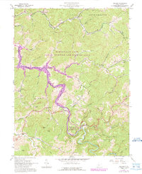
1965 Map of Orlando
USGS Topo · Published 1989About this map
The Little Kanawha River winds through the borderlands of Braxton and Lewis Counties, a landscape defined by sharp ridges and deep hollows like Flesher Run and Riffle Run. This mid-century survey captures a rural Appalachian network of family-named landmarks and small settlements including Orlando and Napier. Genealogists will find numerous local burial grounds such as Ratcliff Cem and Casto Cem, alongside community anchors like St Michaels Ch and the Long Run Sch. The 1989 revisions highlight the creation of the Burnsville Lake Public Hunting and Fishing Area, where the rising waters of the reservoir began to reshape the valley south of Saltlick. Numerous gas and oil wells pepper the hillsides of Collins Settlement, documenting the region's enduring reliance on natural resource extraction alongside traditional farming.
Find a feature on this map
62 named features on this map. Tap any name to fly to it.
Don’t see what you’re looking for? This feature index may not catch every label — zoom into the map to look around manually.
Map Details
Editions of this 1965 Orlando Map
3 editions found
Other maps of this area

1893 · Buckhannon
USGS Topo · 1:125,000

1893 · Sutton
USGS Topo · 1:125,000

1896 · Buckhannon
USGS Topo · 1:125,000

1897 · Buckhannon
USGS Topo · 1:125,000

1906 · Burnsville
USGS Topo · 1:62,500

1908 · Sutton
USGS Topo · 1:48,000

1910 · Sutton Special
USGS Topo · 1:62,500

1912 · Crawford
USGS Topo · 1:48,000

1913 · Hacker Valley
USGS Topo · 1:48,000

1914 · Crawford
USGS Topo · 1:62,500