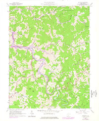
1965 Map of Orlando
USGS Topo · Published 1977About this map
The Little Kanawha River winds through the heart of the central West Virginia hills, marking a landscape defined by small valley settlements and an extensive network of hollows. This mid-1960s survey captures the region just before the waters of Salt Lick Lake would alter the terrain, with purple hatching indicating the future footprint of Burnsville Lake. Vital rural hubs like Orlando and Napier are documented alongside the winding Baltimore and Ohio railroad line. The map is particularly rich for local historians, recording numerous family-named landmarks and essential community institutions such as St Michaels Ch, Clover Fork Ch, and the Long Run Sch. Scores of small operations, labeled simply as Gas Well and Oil Well, dot the ridges, reflecting the long-standing extraction economy of Braxton and Lewis counties.
Find a feature on this map
76 named features on this map. Tap any name to fly to it.
Don’t see what you’re looking for? This feature index may not catch every label — zoom into the map to look around manually.
Map Details
Editions of this 1965 Orlando Map
3 editions found
Other maps of this area

1893 · Buckhannon
USGS Topo · 1:125,000

1893 · Sutton
USGS Topo · 1:125,000

1896 · Buckhannon
USGS Topo · 1:125,000

1897 · Buckhannon
USGS Topo · 1:125,000

1906 · Burnsville
USGS Topo · 1:62,500

1908 · Sutton
USGS Topo · 1:48,000

1910 · Sutton Special
USGS Topo · 1:62,500

1912 · Crawford
USGS Topo · 1:48,000

1913 · Hacker Valley
USGS Topo · 1:48,000

1914 · Crawford
USGS Topo · 1:62,500