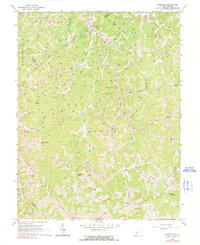
1965 Map of Rosedale
USGS Topo · Published 1991About this map
Rosedale and the surrounding drainage of Steer Creek define this rural landscape on the border of Braxton and Gilmer Counties. This mid-1960s survey documents a network of small upland settlements and hollows, where life centered around landmarks like the Lower Sleith Sch and Upper Sleith Ch. The terrain is marked by family-named peaks such as Eli Taylor Knob and Boar Knob, rising above narrow valleys like Lynncamp Run.
Find a feature on this map
66 named features on this map. Tap any name to fly to it.
Don’t see what you’re looking for? This feature index may not catch every label — zoom into the map to look around manually.
Map Details
Editions of this 1965 Rosedale Map
2 editions found
Other maps of this area

1893 · Sutton
USGS Topo · 1:125,000

1906 · Glenville
USGS Topo · 1:62,500

1906 · Otter
USGS Topo · 1:62,500

1907 · Otter
USGS Topo · 1:62,500

1907 · Arnoldsburg
USGS Topo · 1:62,500

1908 · Gassaway
USGS Topo · 1:48,000

1910 · Gassaway
USGS Topo · 1:62,500

1925 · Glenville
USGS Topo · 1:62,500

1925 · Arnoldsburg
USGS Topo · 1:62,500

1927 · Arnoldsburg
USGS Topo · 1:62,500