1990s Maps of Clay County, West Virginia
Explore 4 historic maps of Clay County from the 1990s. These maps offer a rare glimpse into what life looked like during the 1990s — showing old roads, neighborhoods, homes, and landmarks that have changed or disappeared over time.
Whether you're researching your family's past, planning a metal detecting trip, or studying how Clay County's landscape evolved across the 1990s, these high-resolution maps are a powerful tool for exploring the history of this region.
- Focus on a specific era: All maps on this page are from the 1990s, giving you a focused view of this time period.
- See what’s changed: Compare century-old streets, trails, and buildings to today's modern landscape using overlays and satellite layers.
- Research with precision: Use these maps for genealogy, historical research, land use analysis, or educational projects.
- View, download, or print: Maps are fully viewable online in high resolution, and can be downloaded or printed for your own records.
Start exploring Clay County's history through authentic maps from the 1990s. This is your window into the past.
Clay County, WV maps
(4)- 1996 Map of Bentree, 2002 Print
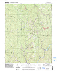 1996 Bentree2002 Print · USGSNear the intersection of four West Virginia counties in the 1990s, this area reflects a landscape shaped by coal production and creek-side settlements. Genealogists and historians can trace community roots through landmarks like Lilly No. 11 School, Lizemores Ch, and the strip mines near Bentree.
 - 1996 Map of Lockwood, 2002 Print
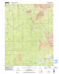 1996 Lockwood2002 Print · USGSThe Nicholas and Clay county borderlands in the 1990s are defined by deep Appalachian valleys and an active extraction economy. Genealogists and historians can trace local landmarks like Lyonsville, the Otter Creek Sch, and the Twentymile Ch among the timbered hills.
 - 1996 Map of Gilboa, 2002 Print
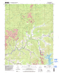 1996 Gilboa2002 Print · USGSNicholas County in the mid-1990s reveals a landscape defined by industrial extraction and rural community hubs. Researchers can trace family history through local landmarks like Enon Ch, Pierson Chapel, and the Lone Star Lookout Tower near Gilboa.
 - 1996 Map of Mammoth, 2003 Print
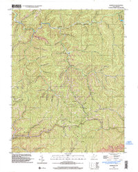 1996 Mammoth2003 Print · USGSNear the border of Kanawha and Clay counties in the late 1990s, these mountain hollows reveal a landscape of small coal settlements and mountain churches. Genealogists can trace family locations near Mammoth, Pond Gap, and Kendalia, or find rural landmarks like Mt Zion Ch and Laurel Fork Sch.
End of results
Showing maps 1-4 of 4
Top cities of Clay County
Frequently asked questions
- What are the different types of historical maps available for Clay County?
- What is the oldest map of Clay County?
- Where can I purchase historical maps of Clay County for my home or office?
- Where can I download high-res historical maps of Clay County?
- Are there historical topographic maps available for Clay County?
- Is there historical aerial imagery available for Clay County?
- Where are historical maps of Clay County sourced from?