1990s Maps of Marting, West Virginia
Explore 1 historic maps of Marting from the 1990s. These maps offer a rare glimpse into what life looked like during the 1990s — showing old roads, neighborhoods, homes, and landmarks that have changed or disappeared over time.
Whether you're researching your family's past, planning a metal detecting trip, or studying how Marting's landscape evolved across the 1990s, these high-resolution maps are a powerful tool for exploring the history of this region.
- Focus on a specific era: All maps on this page are from the 1990s, giving you a focused view of this time period.
- See what’s changed: Compare century-old streets, trails, and buildings to today's modern landscape using overlays and satellite layers.
- Research with precision: Use these maps for genealogy, historical research, land use analysis, or educational projects.
- View, download, or print: Maps are fully viewable online in high resolution, and can be downloaded or printed for your own records.
Start exploring Marting's history through authentic maps from the 1990s. This is your window into the past.
Marting, WV maps
(1)- 1996 Map of Montgomery, 2002 Print
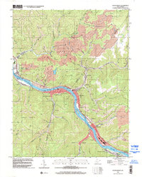 1996 Montgomery2002 Print · USGSThe Kanawha River valley serves as a bustling industrial corridor in the late nineties, anchored by the river-and-rail infrastructure of the coalfields. Researchers can trace the layout of the West Virginia Institute of Technology or locate family sites like Guthrie Cem and Mt Zion Ch.
End of results
Showing maps 1-1 of 1
Top cities near Marting
- Oak Hill historical maps
- Fayetteville historical maps
- Montgomery historical maps
- Ansted historical maps
- East Bank historical maps
- Cedar Grove historical maps
See more
Frequently asked questions
- What are the different types of historical maps available for Marting?
- What is the oldest map of Marting?
- Where can I purchase historical maps of Marting for my home or office?
- Where can I download high-res historical maps of Marting?
- Are there historical topographic maps available for Marting?
- Is there historical aerial imagery available for Marting?
- Where are historical maps of Marting sourced from?