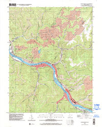
1996 Map of Montgomery
USGS Topo · Published 2002About this map
The Kanawha River carves a deep valley through the heart of the West Virginia coalfields, serving as the primary industrial corridor for settlements like Montgomery, Smithers, and Cannelton. This mid-1990s survey illustrates a landscape defined by the extraction economy and river navigation, with numerous Strip Mines and air shafts dotting the high ridges above the water. Along the riverbank, the CSX Transportation rail line and the London Lock & Dam No 3 facilitate the movement of resources through the valley.
Find a feature on this map
78 named features on this map. Tap any name to fly to it.
Don’t see what you’re looking for? This feature index may not catch every label — zoom into the map to look around manually.
Map Details
Editions of this 1996 Montgomery Map
This is the sole edition of this map. No revisions or reprints were ever made.
Other maps of this area

1897 · Kanawha Falls
USGS Topo · 1:125,000

1900 · Kanawha Falls
USGS Topo · 1:125,000

1901 · Kanawha Falls
USGS Topo · 1:125,000

1907 · Clendenin
USGS Topo · 1:62,500

1908 · Clay
USGS Topo · 1:48,000

1908 · Fayetteville
USGS Topo · 1:48,000

1908 · Montgomery
USGS Topo · 1:48,000

1909 · Clendenin
USGS Topo · 1:62,500

1910 · Clay
USGS Topo · 1:62,500

1910 · Fayetteville
USGS Topo · 1:62,500