1900s (20th Century) Maps of Red Spring, West Virginia
Explore 8 historic maps of Red Spring from the 1900s (20th Century). These maps offer a rare glimpse into what life looked like during the 1900s — showing old roads, neighborhoods, homes, and landmarks that have changed or disappeared over time.
Whether you're researching your family's past, planning a metal detecting trip, or studying how Red Spring's landscape evolved across the 1900s, these high-resolution maps are a powerful tool for exploring the history of this region.
- Focus on a specific era: All maps on this page are from the 1900s, giving you a focused view of this time period.
- See what’s changed: Compare century-old streets, trails, and buildings to today's modern landscape using overlays and satellite layers.
- Research with precision: Use these maps for genealogy, historical research, land use analysis, or educational projects.
- View, download, or print: Maps are fully viewable online in high resolution, and can be downloaded or printed for your own records.
Start exploring Red Spring's history through authentic maps from the 1900s. This is your window into the past.
Red Spring, WV maps
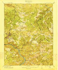
(8)- 1912 Map of Meadow Creek
 1912 Meadow Creek1912 Print · USGSWest Virginia's Fayette and Greenbrier borderlands are captured here in the early twentieth century, showing a landscape of timber and mountain settlements. Genealogists can locate dozens of country schools like Rock of Ages School and Eureka School, alongside the Sandstone Falls on the New River.3 unique versions available
 - 1915 Map of Meadow Creek
 1915 Meadow Creek1915 Print · USGSThe West Virginia highlands come to life in this detailed survey of the mountain ridges and river valleys just before the First World War. Genealogists can locate dozens of country schools and remote post offices like Rock of Ages School, Brownwood Lawton P.O., and Layland.3 unique versions available
 - 1955 Map of Bluefield
 1955 Bluefield1955 Print · USGSThe Central Appalachian borderlands come alive in the mid-fifties, showing the coal and rail networks connecting Bluefield to Beckley. Researchers can trace the industrial landscape of the New River Ordnance Plant and the terrain of Burkes Garden.
 - 1957 Map of Bluefield, 1967 Print
 1957 Bluefield1967 Print · USGSThe heart of Central Appalachia in the mid-fifties is defined by the winding rail lines and river valleys of the coalfields. Researchers can trace the industrial footprints of towns like Welch and Princeton or locate landmarks such as the Bluestone Reservoir and Claytor Lake.2 unique versions available
 - 1961 Map of Bluefield
 1961 Bluefield1961 Print · USGSThe coalfields and mountain ridges of southern West Virginia and southwest Virginia are captured in the early sixties. Genealogists can trace family ties through rail-linked towns like Princeton and Richlands or along the shores of Bluestone Reservoir.
 - 1969 Map of Meadow Creek, 1974 Print
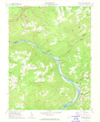 1969 Meadow Creek1974 Print · USGSThe New River gorge in the late 1960s shows a landscape defined by steep ridges and riverside rail lines. Researchers can trace family history at Little Laurel Ch, locate the Sandstone High Sch, or find industrial sites like the Tipple near Backus.2 unique versions available
 - 1984 Map of Lewisburg, 1985 Print
 1984 Lewisburg1985 Print · USGSThe Greenbrier Valley in the mid-eighties shows a landscape of river-town commerce, mountain agriculture, and major institutional landmarks. Researchers can trace the rail corridors of the Chesapeake and Ohio and locate sites like the Federal Reformatory for Women and the Sam Black Church.2 unique versions available
 - 1996 Map of Meadow Creek, 2002 Print
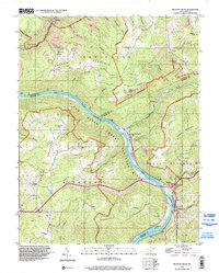 1996 Meadow Creek2002 Print · USGSThe New River Gorge area in the late twentieth century reveals a landscape of ridge-top mining and river-bottom settlements. Researchers can trace rural genealogy through the Oak Grove Ch, the Sandstone High Sch, and family landmarks near Sandstone Falls.
End of results
Showing maps 1-8 of 8
Top cities near Red Spring
- Oak Hill historical maps
- Fayetteville historical maps
- Hinton historical maps
- Rainelle historical maps
- Rupert historical maps
- Quinwood historical maps
See more
Frequently asked questions
- What are the different types of historical maps available for Red Spring?
- What is the oldest map of Red Spring?
- Where can I purchase historical maps of Red Spring for my home or office?
- Where can I download high-res historical maps of Red Spring?
- Are there historical topographic maps available for Red Spring?
- Is there historical aerial imagery available for Red Spring?
- Where are historical maps of Red Spring sourced from?