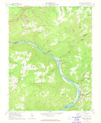
1969 Map of Meadow Creek
USGS Topo · Published 1974About this map
The New River carves a deep path through the West Virginia highlands in this late-1960s survey, dictating the placement of infrastructure and settlements. The Chesapeake and Ohio railroad follows the river's winding banks, connecting the riverside community of Meadow Creek and the settlement of Sandstone near the broad Sandstone Falls. Higher elevations are defined by the prominent Backus Mountain and Irish Mountain, where scattered mountain life is documented through landmarks like Little Laurel Ch, Oak Grove Ch, and the Harrah Cem. Industrial activity is evident on the ridges, with a Tipple and Conveyor marked near the Mine and various Strip Mine operations. This map provides a detailed view of the Fayette, Summers, and Raleigh county borders as they converge in the steep terrain of the New Haven and Green Sulphur districts.
Find a feature on this map
70 named features on this map. Tap any name to fly to it.
Don’t see what you’re looking for? This feature index may not catch every label — zoom into the map to look around manually.
Map Details
Editions of this 1969 Meadow Creek Map
2 editions found
Other maps of this area

1887 · Hinton
USGS Topo · 1:125,000

1891 · Raleigh
USGS Topo · 1:125,000

1892 · Hinton
USGS Topo · 1:125,000

1897 · Raleigh
USGS Topo · 1:125,000

1902 · Raleigh
USGS Topo · 1:125,000

1911 · Flattop
USGS Topo · 1:48,000

1911 · Beckley
USGS Topo · 1:48,000

1912 · Meadow Creek
USGS Topo · 1:48,000

1912 · Big Bend
USGS Topo · 1:62,500

1913 · Beckley
USGS Topo · 1:62,500