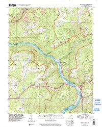
1996 Map of Meadow Creek
USGS Topo · Published 2002About this map
The New River carves a deep path through this portion of southern West Virginia, defining the landscape within the New River Gorge National River. This 1996 update, based on 1969 topography, illustrates a region shaped by coal and timber, with several Former Mines and a Strip Mine scattered across the high ridges of New Haven Mountain and Rich Mountain. The map captures the social infrastructure of small mountain communities through numerous educational and spiritual landmarks, including Little Laurel Sch, Glendale Sch, and the Oak Grove Ch.
Find a feature on this map
67 named features on this map. Tap any name to fly to it.
Don’t see what you’re looking for? This feature index may not catch every label — zoom into the map to look around manually.
Map Details
Editions of this 1996 Meadow Creek Map
This is the sole edition of this map. No revisions or reprints were ever made.
Other maps of this area

1887 · Hinton
USGS Topo · 1:125,000

1891 · Raleigh
USGS Topo · 1:125,000

1892 · Hinton
USGS Topo · 1:125,000

1897 · Raleigh
USGS Topo · 1:125,000

1902 · Raleigh
USGS Topo · 1:125,000

1911 · Flattop
USGS Topo · 1:48,000

1911 · Beckley
USGS Topo · 1:48,000

1912 · Meadow Creek
USGS Topo · 1:48,000

1912 · Big Bend
USGS Topo · 1:62,500

1913 · Beckley
USGS Topo · 1:62,500