1940s Maps of Grant County, West Virginia
Explore 8 historic maps of Grant County from the 1940s. These maps offer a rare glimpse into what life looked like during the 1940s — showing old roads, neighborhoods, homes, and landmarks that have changed or disappeared over time.
Whether you're researching your family's past, planning a metal detecting trip, or studying how Grant County's landscape evolved across the 1940s, these high-resolution maps are a powerful tool for exploring the history of this region.
- Focus on a specific era: All maps on this page are from the 1940s, giving you a focused view of this time period.
- See what’s changed: Compare century-old streets, trails, and buildings to today's modern landscape using overlays and satellite layers.
- Research with precision: Use these maps for genealogy, historical research, land use analysis, or educational projects.
- View, download, or print: Maps are fully viewable online in high resolution, and can be downloaded or printed for your own records.
Start exploring Grant County's history through authentic maps from the 1940s. This is your window into the past.
Grant County, WV maps
(8)- 1945 Map of Moorefield
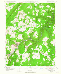
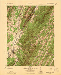 1945 Moorefield1945 Print · USGSHardy and Hampshire counties at the close of World War II reveal a landscape defined by the Potomac river-and-rail economy. Genealogists can locate family landmarks like Reynolds Gap and rural centers such as Old Pine Ch and Bethel Sch.
 - 1948 Map of Cumberland
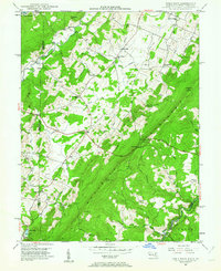
 1948 Cumberland1948 Print · USGSMid-century Appalachia and the Shenandoah Valley are shown in detail, documenting the industrial and transportation hubs of the tri-state area. Genealogists can trace family roots through settlements like Double Tollgate and Bunker Hill or along the Baltimore & Ohio RR.3 unique versions available
 - 1948 Map of Table Rock, 1962 Print
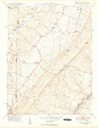
 1948 Table Rock1962 Print · USGSGarrett County high country and the West Virginia borderlands appear here as they were just after the war. Researchers can trace rural life through landmarks like Sunnyside School and Gnegy Church or follow the Western Maryland Railroad through Wilson.5 unique versions available
 - 1949 Map of Table Rock
 1949 Table Rock1949 Print · USGSThe Garrett County highlands and the West Virginia borderlands meet here in the late 1940s, split by the massive ridge of Little Backbone Mountain. Genealogists can trace family footprints at Beckman Cem, Gnegy Ch, or the vanished schoolrooms of Lyndale Sch.2 unique versions available
 - 1949 Map of Kempton
 1949 Kempton1949 Print · USGSThe high plateau of the Maryland-West Virginia border comes into focus in the late 1940s, highlighting the industrial rail corridor along the Potomac River. Genealogists can trace the rural landscape around Kempton, Henry, and the historic Fairfax Stone monument.2 unique versions available
 - 1949 Map of Charlottesville
 1949 Charlottesville1949 Print · USGSThe Shenandoah Valley and Blue Ridge appear in the late 1940s as a thriving corridor of rail and river commerce. Researchers can trace the mid-century footprints of Harrisonburg, Staunton, and Culpeper alongside the historic routes of the Southern Railway.2 unique versions available
 - 1949 Map of Gorman, 1965 Print
 1949 Gorman1965 Print · USGSThe North Branch Potomac River valley in the late 1940s reveals a landscape of mountain farming and rail-bound industry. Genealogists can trace family landmarks like Harvey-Wilson Cem, the historic Fort Pendleton, and the river crossing at Gormania.4 unique versions available
 - 1949 Map of Mount Storm, 1972 Print
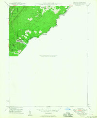
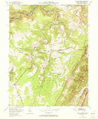 1949 Mount Storm1972 Print · USGSThe West Virginia highlands are captured here in the late 1940s, showing the industrial pulse of the coal mines along the Allegheny Front. Genealogists can trace local roots through the White Hall Sch and family sites like the Dixon Cem or Schaeffer Cem.4 unique versions available
End of results
Showing maps 1-8 of 8
Top cities of Grant County
Frequently asked questions
- What are the different types of historical maps available for Grant County?
- What is the oldest map of Grant County?
- Where can I purchase historical maps of Grant County for my home or office?
- Where can I download high-res historical maps of Grant County?
- Are there historical topographic maps available for Grant County?
- Is there historical aerial imagery available for Grant County?
- Where are historical maps of Grant County sourced from?