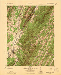
1945 Map of Moorefield
USGS Topo · Published 1945About this map
The South Branch Potomac River valley serves as the primary corridor for settlement and transit in this 1940s-era survey. The Baltimore and Ohio railroad snakes alongside the river, connecting riverside communities like McNeill and Old Fields to the regional hub at Moorefield. This agricultural and industrial lifeline is contrasted by the high ridges of Moorefield Ridge and Big Ridge, where small mountain schools and churches indicate a more dispersed, rural way of life.
Find a feature on this map
68 named features on this map. Tap any name to fly to it.
Don’t see what you’re looking for? This feature index may not catch every label — zoom into the map to look around manually.
Map Details
Editions of this 1945 Moorefield Map
This is the sole edition of this map. No revisions or reprints were ever made.
Other maps of this area

1891 · Romney
USGS Topo · 1:125,000

1892 · Franklin
USGS Topo · 1:125,000

1892 · Woodstock
USGS Topo · 1:125,000

1895 · Piedmont
USGS Topo · 1:125,000

1896 · Franklin
USGS Topo · 1:125,000

1919 · Elk Garden
USGS Topo · 1:48,000

1920 · Elk Garden
USGS Topo · 1:48,000

1920 · Petersburg
USGS Topo · 1:48,000

1920 · Moorefield
USGS Topo · 1:62,500

1920 · Keyser
USGS Topo · 1:62,500