1970s Maps of Julia, West Virginia
Explore 3 historic maps of Julia from the 1970s. These maps offer a rare glimpse into what life looked like during the 1970s — showing old roads, neighborhoods, homes, and landmarks that have changed or disappeared over time.
Whether you're researching your family's past, planning a metal detecting trip, or studying how Julia's landscape evolved across the 1970s, these high-resolution maps are a powerful tool for exploring the history of this region.
- Focus on a specific era: All maps on this page are from the 1970s, giving you a focused view of this time period.
- See what’s changed: Compare century-old streets, trails, and buildings to today's modern landscape using overlays and satellite layers.
- Research with precision: Use these maps for genealogy, historical research, land use analysis, or educational projects.
- View, download, or print: Maps are fully viewable online in high resolution, and can be downloaded or printed for your own records.
Start exploring Julia's history through authentic maps from the 1970s. This is your window into the past.
Julia, WV maps
(3)- 1973 Map of Droop, 1989 Print
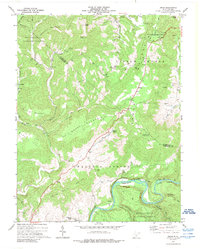 1973 Droop1989 Print · USGSHighland ridges and river valleys define this part of Greenbrier County in the early seventies, centered on the site of a historic battlefield. Local researchers can trace family names and landmarks like Renicks Valley, Mt Zion Ch, and the Covered Bridge along Locust Creek.
 - 1977 Map of Droop, 1978 Print
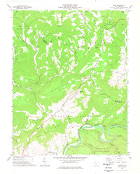 1977 Droop1978 Print · USGSGreenbrier and Pocahontas counties meet in this mid-1970s mountain survey, where high ridges overlook the river-and-rail corridor. You can trace family sites near Whiteoak Grove, locate the Covered Bridge at Droop, and explore the grounds of Droop Mountain Battlefield State Park.
 - 1979 Map of Marlinton, 1982 Print
 1979 Marlinton1982 Print · USGSThe West Virginia highlands are shown in detail during the late seventies, featuring the dense rail networks and mountain towns of the Allegheny range. Researchers can trace family roots through sites like Buckeye Cem, Mount Nebo Ch, and the lumber and coal hubs of Richwood and Rainelle.
End of results
Showing maps 1-3 of 3
Top cities near Julia
- Lewisburg historical maps
- Richwood historical maps
- White Sulphur Springs historical maps
- Marlinton historical maps
- Hillsboro historical maps
- Falling Spring historical maps
Frequently asked questions
- What are the different types of historical maps available for Julia?
- What is the oldest map of Julia?
- Where can I purchase historical maps of Julia for my home or office?
- Where can I download high-res historical maps of Julia?
- Are there historical topographic maps available for Julia?
- Is there historical aerial imagery available for Julia?
- Where are historical maps of Julia sourced from?