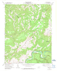
1973 Map of Droop
USGS Topo · Published 1989About this map
Droop Mountain Battlefield State Park dominates the high ground in the eastern portion of this West Virginia survey, marking the site of a significant Civil War engagement. The landscape transitions from the dense timber of the Monongahela National Forest on Kennison Mountain and Falling Spring Mountain to the agricultural pocket of Little Levels. The Greenbrier River carves a winding path through the southern edge of the quadrangle, shadowed by the Chesapeake and Ohio railroad line. Small rural settlements like Droop, Renicks Valley, and Modoc are connected by mountain gaps and valleys, anchored by local institutions such as Hills Chapel, Bethel Ch, and several family cemeteries including Kellison Cemetery. The presence of Beartown State Park and a Covered Bridge near Locust Creek highlights the area's geological and architectural heritage in the early 1970s.
Find a feature on this map
63 named features on this map. Tap any name to fly to it.
Don’t see what you’re looking for? This feature index may not catch every label — zoom into the map to look around manually.
Map Details
Editions of this 1973 Droop Map
This is the sole edition of this map. No revisions or reprints were ever made.
Other maps of this area

1887 · Lewisburg
USGS Topo · 1:125,000

1891 · Lewisburg
USGS Topo · 1:125,000

1891 · Huntersville
USGS Topo · 1:125,000

1894 · Huntersville
USGS Topo · 1:125,000

1921 · Callaghan
USGS Topo · 1:48,000

1921 · White Sulphur Springs
USGS Topo · 1:48,000

1923 · Lobelia
USGS Topo · 1:48,000

1923 · White Sulphur Springs
USGS Topo · 1:62,500

1923 · Marlinton
USGS Topo · 1:48,000

1923 · Callaghan
USGS Topo · 1:62,500