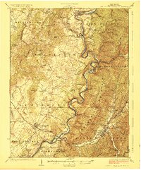
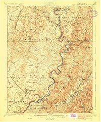
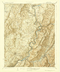
1923 Map of White Sulphur Springs
USGS Topo · Published 1923About this map
The Greenbrier River carves a dramatic path through this 1923 survey, dictating the development of transport and settlement in eastern West Virginia. The Chesapeake and Ohio RR follows the river's winding course through North Caldwell and Caldwell, while the historic Kanawha and James River Turnpike cuts across the landscape through the regional hub of Lewisburg. The map reveals a dense network of early 20th-century rural infrastructure, particularly the high concentration of one-room schoolhouses like Carroll Hill School and Gravelpoint School that served the farming communities of Frankford and Williamsburg. Genealogists will find significant value in the documentation of family-named landmarks and early sites such as Mathews Fort and Pilgrims Rest, alongside established towns including White Sulphur Springs and Ronceverte.
Find a feature on this map
91 named features on this map. Tap any name to fly to it.
Don’t see what you’re looking for? This feature index may not catch every label — zoom into the map to look around manually.
Map Details
Editions of this 1923 White Sulphur Springs Map
3 editions found
Other maps of this area

1887 · Hinton
USGS Topo · 1:125,000

1887 · Lewisburg
USGS Topo · 1:125,000

1889 · Nicholas
USGS Topo · 1:125,000

1891 · Lewisburg
USGS Topo · 1:125,000

1891 · Nicholas
USGS Topo · 1:125,000

1891 · Huntersville
USGS Topo · 1:125,000

1892 · Hinton
USGS Topo · 1:125,000

1894 · Huntersville
USGS Topo · 1:125,000

1901 · Nicholas
USGS Topo · 1:125,000
1918 · Richwood
USGS Topo · 1:62,500