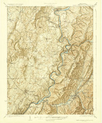
1923 Map of White Sulphur Springs
USGS Topo · Published 1923About this map
Lewisburg and White Sulphur Springs anchor this 1923 portrait of Greenbrier County, where the high-altitude landscape is defined by the winding Greenbrier River and the transit corridors of the Chesapeake and Ohio RR. The map illustrates a rural society deeply connected by neighborhood institutions, featuring dozens of small schools such as Balm of Gilead School, Chestnut Flat School, and Solomon Springs School. Historic transportation routes like the James River and Kanawha Turnpike and the Stone House Road cut across the ridges, linking settlements such as Frankford and Williamsburg. Along the river valley, industry and commerce are marked by stops like Renick PO and Sta and Judyton PO Keister Sta, while family-named landmarks like Wicks Knob and O'Neill Knob rise above the drainage of Anthony Creek.
Find a feature on this map
104 named features on this map. Tap any name to fly to it.
Don’t see what you’re looking for? This feature index may not catch every label — zoom into the map to look around manually.
Map Details
Editions of this 1923 White Sulphur Springs Map
3 editions found

Other maps of this area

1887 · Hinton
USGS Topo · 1:125,000

1887 · Lewisburg
USGS Topo · 1:125,000

1889 · Nicholas
USGS Topo · 1:125,000

1891 · Lewisburg
USGS Topo · 1:125,000

1891 · Nicholas
USGS Topo · 1:125,000

1891 · Huntersville
USGS Topo · 1:125,000

1892 · Hinton
USGS Topo · 1:125,000

1894 · Huntersville
USGS Topo · 1:125,000

1901 · Nicholas
USGS Topo · 1:125,000

1918 · Richwood
USGS Topo · 1:62,500