1920s Maps of Romney, West Virginia
Explore 5 historic maps of Romney from the 1920s. These maps offer a rare glimpse into what life looked like during the 1920s — showing old roads, neighborhoods, homes, and landmarks that have changed or disappeared over time.
Whether you're researching your family's past, planning a metal detecting trip, or studying how Romney's landscape evolved across the 1920s, these high-resolution maps are a powerful tool for exploring the history of this region.
- Focus on a specific era: All maps on this page are from the 1920s, giving you a focused view of this time period.
- See what’s changed: Compare century-old streets, trails, and buildings to today's modern landscape using overlays and satellite layers.
- Research with precision: Use these maps for genealogy, historical research, land use analysis, or educational projects.
- View, download, or print: Maps are fully viewable online in high resolution, and can be downloaded or printed for your own records.
Start exploring Romney's history through authentic maps from the 1920s. This is your window into the past.
Romney, WV maps
(5)- 1920 Map of Keyser, 1964 Print
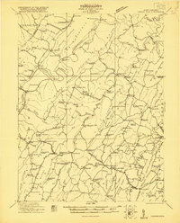
 1920 Keyser1964 Print · USGSMineral and Hampshire counties in the 1920s reveal a landscape of deep river valleys and prominent ridges tied together by the Baltimore and Ohio RR. Researchers can locate dozens of country schools and churches, from Trinity Church to the Pancake School and Reeses Mill.
 - 1921 Map of Keyser
 1921 Keyser1921 Print · USGSThe Potomac River valley and the ridges of Mineral and Hampshire counties are captured here in the early twenties. Researchers can locate vanished landmarks like the Russellville PO, industrial sites at Ochre, and dozens of rural schoolhouses from Red Star School to Knobly School.2 unique versions available
 - 1921 Map of Hanging Rock
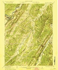
 1921 Hanging Rock1921 Print · USGSHampshire County in the early twentieth century is captured here as a landscape of isolated mountain hollows and river settlements. Genealogists can locate dozens of neighborhood landmarks like Milesons Mill, Tearcoat Church, and schools such as Shady Grove School.3 unique versions available
 - 1922 Map of Keyser
 1922 Keyser1922 Print · USGSThe Potomac borderlands in the early 1920s reveal a landscape of deep valleys and vital rail connections along the West Virginia-Maryland line. Genealogists and local historians can trace rural family life through dozens of named schools like Red Star School and historic landmarks such as Trinity Church and Vanderlip P.O.3 unique versions available
 - 1923 Map of Hanging Rock
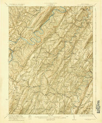 1923 Hanging Rock1923 Print · USGSHampshire County at the start of the twenties is captured here as a landscape of ridge-top schools and valley mills. Researchers can trace the Northwestern Turnpike or locate vanished landmarks like Millesons Mill, Three Churches, and the Baltimore and Ohio RR.4 unique versions available
End of results
Showing maps 1-5 of 5
Top cities near Romney
- Keyser historical maps
- Lonaconing historical maps
- Rawlings historical maps
- McCoole historical maps
- Bier historical maps
Top neighborhoods of Romney
- Valley historical maps
- Romney Junction historical maps
- Homewood Addition historical maps
- Loy-Long Addition historical maps
Frequently asked questions
- What are the different types of historical maps available for Romney?
- What is the oldest map of Romney?
- Where can I purchase historical maps of Romney for my home or office?
- Where can I download high-res historical maps of Romney?
- Are there historical topographic maps available for Romney?
- Is there historical aerial imagery available for Romney?
- Where are historical maps of Romney sourced from?