1920s Maps of Harrison County, West Virginia
Explore 11 historic maps of Harrison County from the 1920s. These maps offer a rare glimpse into what life looked like during the 1920s — showing old roads, neighborhoods, homes, and landmarks that have changed or disappeared over time.
Whether you're researching your family's past, planning a metal detecting trip, or studying how Harrison County's landscape evolved across the 1920s, these high-resolution maps are a powerful tool for exploring the history of this region.
- Focus on a specific era: All maps on this page are from the 1920s, giving you a focused view of this time period.
- See what’s changed: Compare century-old streets, trails, and buildings to today's modern landscape using overlays and satellite layers.
- Research with precision: Use these maps for genealogy, historical research, land use analysis, or educational projects.
- View, download, or print: Maps are fully viewable online in high resolution, and can be downloaded or printed for your own records.
Start exploring Harrison County's history through authentic maps from the 1920s. This is your window into the past.
Harrison County, WV maps
(11)- 1923 Map of Fairmont, 1956 Print
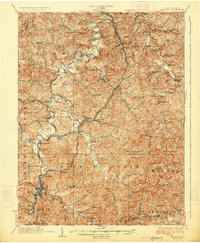
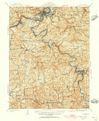 1923 Fairmont1956 Print · USGSMarion and Taylor counties are shown during the height of their rail and coal era in the early twentieth century. Researchers can trace family origins through dozens of named landmarks like Jane Memorial Church, T McConnell Mines, and the river crossing at Benton Ferry.2 unique versions available
 - 1923 Map of Clarksburg, 1959 Print
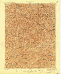
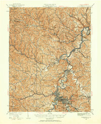 1923 Clarksburg1959 Print · USGSHarrison and Marion counties appear in the 1920s as a landscape of coal mines and mountain schoolhouses. Trace family roots at Bethel Church or Annabelle, and locate old industrial sites like Cook Mine and Straus Mill along the rivers.
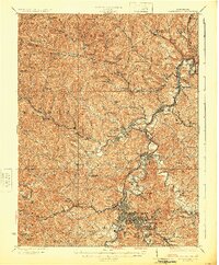
 - 1924 Map of Centerpoint, 1957 Print
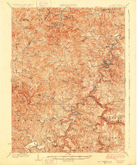
 1924 Centerpoint1957 Print · USGSDoddridge and Harrison counties are shown here in the mid-1920s, when small-town life revolved around the railroad and local schoolhouses. Genealogists can locate family homesteads near landmarks like Alvy P O Stringtown, Smithton Smithburg Sta, and Fairview Church.2 unique versions available
 - 1925 Map of Clarksburg
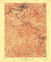
 1925 Clarksburg1925 Print · USGSHarrison County in the mid-twenties is a bustling corridor of coal mining and rail activity centered on the West Fork River. Genealogists can trace family roots through dozens of named rural schools like Lower Davisson Run School or locate vanished industrial sites like Ocean Mine and Sturms Mill.3 unique versions available
 - 1925 Map of Centerpoint
 1925 Centerpoint1925 Print · USGSDoddridge and Harrison counties are shown here in the mid-1920s, highlighting a landscape of deep hollows and ridge-top farms. Researchers can trace the Baltimore and Ohio rail line through Salem or find small rural landmarks like Victory Church and Lima PO.4 unique versions available
 - 1925 Map of Philippi, 1954 Print
 1925 Philippi1954 Print · USGSIn the mid-1920s, the Tygart River valley was a busy corridor of coal settlements and river commerce. Genealogists can locate family homesteads near vanished landmarks like Brownton PO, Pigtail School, and the Electric Line near Galloway.
 - 1925 Map of Vadis, 1981 Print
 1925 Vadis1981 Print · USGSCentral West Virginia's highlands in the mid-twenties reveal a landscape of hollows and ridges dotted with one-room schoolhouses and country parishes. Genealogists can trace family roots through numerous sites like St Marys Church, Vadis, and Lower Walnut School.
 - 1926 Map of Fairmont
 1926 Fairmont1926 Print · USGSMarion and Taylor counties are shown during the mid-twenties when coal mining and the rail industry shaped the river valleys. Researchers can locate vanished landmarks like the Tyrconnell Mines and community centers such as Pruntytown and Mt Zion Church.3 unique versions available
 - 1926 Map of Weston
 1926 Weston1926 Print · USGSWeston and the West Fork River valley are captured in the mid-twenties as the rail-and-river economy flourished. Genealogists and researchers can trace family-named sites like Jackson Mill, Romines Mills, and the Broad Run Church.4 unique versions available
 - 1927 Map of Vadis
 1927 Vadis1927 Print · USGSWest Virginia's central highlands are shown here in the mid-1920s, a landscape defined by isolated farmsteads and valley-bottom settlements. Genealogists and historians can trace dozens of rural school sites and landmarks like St Boniface Church, Alum Bridge, and Freemansburg.2 unique versions available
 - 1928 Map of Philippi
 1928 Philippi1928 Print · USGSBarbour County is shown here in the mid-twenties as the Baltimore and Ohio railroad connected river towns and coal camps. Researchers can trace ancestral roots through dozens of local landmarks like Adaland, Rangoon PO, and the Pleasant Grove Church.2 unique versions available
End of results
Showing maps 1-11 of 11
Top cities of Harrison County
- Clarksburg historical maps
- Bridgeport historical maps
- Shinnston historical maps
- Salem historical maps
- Stonewood historical maps
- Nutter Fort historical maps
See more
Frequently asked questions
- What are the different types of historical maps available for Harrison County?
- What is the oldest map of Harrison County?
- Where can I purchase historical maps of Harrison County for my home or office?
- Where can I download high-res historical maps of Harrison County?
- Are there historical topographic maps available for Harrison County?
- Is there historical aerial imagery available for Harrison County?
- Where are historical maps of Harrison County sourced from?