1950s Maps of Harrison County, West Virginia
Explore 3 historic maps of Harrison County from the 1950s. These maps offer a rare glimpse into what life looked like during the 1950s — showing old roads, neighborhoods, homes, and landmarks that have changed or disappeared over time.
Whether you're researching your family's past, planning a metal detecting trip, or studying how Harrison County's landscape evolved across the 1950s, these high-resolution maps are a powerful tool for exploring the history of this region.
- Focus on a specific era: All maps on this page are from the 1950s, giving you a focused view of this time period.
- See what’s changed: Compare century-old streets, trails, and buildings to today's modern landscape using overlays and satellite layers.
- Research with precision: Use these maps for genealogy, historical research, land use analysis, or educational projects.
- View, download, or print: Maps are fully viewable online in high resolution, and can be downloaded or printed for your own records.
Start exploring Harrison County's history through authentic maps from the 1950s. This is your window into the past.
Harrison County, WV maps
(3)- 1956 Map of Clarksburg, 1966 Print
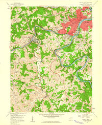
 1956 Clarksburg1966 Print · USGSThe Ohio River valley and the industrial heart of West Virginia are seen here in the mid-1950s as rail and river commerce thrived. Researchers can trace historic transport lines like the Baltimore and Ohio RR and locate ancestral homes in Clarksburg, Moundsville, or Parkersburg.2 unique versions available
 - 1958 Map of Clarksburg, 1960 Print
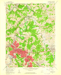 1958 Clarksburg1960 Print · USGSHarrison County in the late fifties shows a bustling industrial landscape centered on the West Fork River. Researchers can trace old neighborhoods and local institutions like Victory High Sch, the Laura Lee Mine, and Stewart Chapel.3 unique versions available
 - 1958 Map of Fairmont West, 1960 Print
 1958 Fairmont West1960 Print · USGSMarion County at the end of the 1950s shows the bustling city of Fairmont as a regional hub of education and transport. Researchers can locate family roots at Mount Calvary Cem, trace the rail lines of the Baltimore and Ohio Railroad, or find old schools like Coons Run Sch.4 unique versions available
End of results
Showing maps 1-3 of 3
Top cities of Harrison County
- Clarksburg historical maps
- Bridgeport historical maps
- Shinnston historical maps
- Salem historical maps
- Stonewood historical maps
- Nutter Fort historical maps
See more
Frequently asked questions
- What are the different types of historical maps available for Harrison County?
- What is the oldest map of Harrison County?
- Where can I purchase historical maps of Harrison County for my home or office?
- Where can I download high-res historical maps of Harrison County?
- Are there historical topographic maps available for Harrison County?
- Is there historical aerial imagery available for Harrison County?
- Where are historical maps of Harrison County sourced from?