1900-1909 Maps of Jackson County, West Virginia
Explore 8 historic maps of Jackson County from 1900-1909. These maps offer a rare glimpse into what life looked like during the 1900s — showing old roads, neighborhoods, homes, and landmarks that have changed or disappeared over time.
Whether you're researching your family's past, planning a metal detecting trip, or studying how Jackson County's landscape evolved across the 1900s, these high-resolution maps are a powerful tool for exploring the history of this region.
- Focus on a specific era: All maps on this page are from the 1900s, giving you a focused view of this time period.
- See what’s changed: Compare century-old streets, trails, and buildings to today's modern landscape using overlays and satellite layers.
- Research with precision: Use these maps for genealogy, historical research, land use analysis, or educational projects.
- View, download, or print: Maps are fully viewable online in high resolution, and can be downloaded or printed for your own records.
Start exploring Jackson County's history through authentic maps from the 1900s. This is your window into the past.
Jackson County, WV maps
(8)- 1906 Map of Belleville
 1906 Belleville1906 Print · USGSWood County at the turn of the century is defined by its deep river valleys and the expansion of the Baltimore and Ohio RR. Genealogists and historians can trace late-Victorian settlements like Mineral Wells, Belleville, and the riverfront at Walkers Crossing.2 unique versions available
 - 1906 Map of Kenna, 1959 Print
 1906 Kenna1959 Print · USGSThe West Virginia hills north of Charleston appear in this early century survey of the Jackson and Kanawha county border. Researchers can locate early homesteads and community hubs like Sissonville, the Emma Belle School, and Staats Mills.
 - 1906 Map of Winfield, 1961 Print
 1906 Winfield1961 Print · USGSThe Kanawha River valley at the turn of the century shows a landscape defined by river locks and the growing influence of the railroad. Genealogists and historians can trace old homesteads and landings from Redhouse Shoals to the small village of Confidence.
 - 1907 Map of Kenna
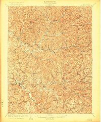
 1907 Kenna1907 Print · USGSThe hill country of Jackson and Kanawha counties is captured here in the early twentieth century as a landscape of isolated valley farms and ridge-top communities. Genealogists can trace family footprints through rural centers like Sissonville, Staats Mills, and White Chapel.3 unique versions available
 - 1907 Map of Keno, 1919 Print
 1907 Keno1919 Print · USGSMeigs County and the Ohio River valley appear in high detail just after the turn of the century, showing a landscape defined by river trade and rail. Researchers can trace family sites at Nease Settlement, find the Minersville PO, or locate old schools like Morningstar School and Redbrush School.3 unique versions available
 - 1907 Map of Ripley, 1922 Print
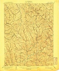
 1907 Ripley1922 Print · USGSJackson County at the start of the twentieth century shows a landscape of ridge-top schools and creek-bottom settlements. Trace early routes like the Buffalo Turnpike or locate family sites at Lockhart PO and Klondike Schoolhouse.
 - 1908 Map of Winfield
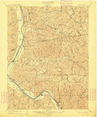 1908 Winfield1908 Print · USGSThe Kanawha River valley at the turn of the century shows a landscape defined by river traffic and rail expansion. Genealogists and historians can trace riverside settlements like Winfield and Buffalo, or find lost rail stops and river locks including Lock No 10 and Black Betsey.3 unique versions available
 - 1908 Map of Ravenswood
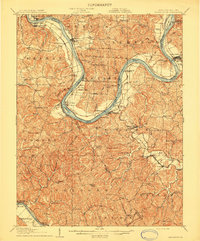 1908 Ravenswood1908 Print · USGSEarly 1900s life along the Ohio River comes alive in this survey of the West Virginia and Ohio borderlands. Genealogists and historians can trace family locations near landmarks like Antioch Church, Letart Falls, and the old K and M RR line.2 unique versions available
End of results
Showing maps 1-8 of 8
Top cities of Jackson County
Frequently asked questions
- What are the different types of historical maps available for Jackson County?
- What is the oldest map of Jackson County?
- Where can I purchase historical maps of Jackson County for my home or office?
- Where can I download high-res historical maps of Jackson County?
- Are there historical topographic maps available for Jackson County?
- Is there historical aerial imagery available for Jackson County?
- Where are historical maps of Jackson County sourced from?