1900-1909 Maps of Ravenswood, West Virginia
Explore 2 historic maps of Ravenswood from 1900-1909. These maps offer a rare glimpse into what life looked like during the 1900s — showing old roads, neighborhoods, homes, and landmarks that have changed or disappeared over time.
Whether you're researching your family's past, planning a metal detecting trip, or studying how Ravenswood's landscape evolved across the 1900s, these high-resolution maps are a powerful tool for exploring the history of this region.
- Focus on a specific era: All maps on this page are from the 1900s, giving you a focused view of this time period.
- See what’s changed: Compare century-old streets, trails, and buildings to today's modern landscape using overlays and satellite layers.
- Research with precision: Use these maps for genealogy, historical research, land use analysis, or educational projects.
- View, download, or print: Maps are fully viewable online in high resolution, and can be downloaded or printed for your own records.
Start exploring Ravenswood's history through authentic maps from the 1900s. This is your window into the past.
Ravenswood, WV maps
(2)- 1907 Map of Ripley, 1922 Print
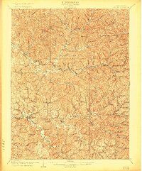 1907 Ripley1922 Print · USGSJackson County at the start of the twentieth century shows a landscape of ridge-top schools and creek-bottom settlements. Trace early routes like the Buffalo Turnpike or locate family sites at Lockhart PO and Klondike Schoolhouse.
 - 1908 Map of Ravenswood
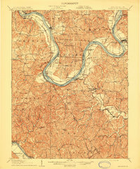 1908 Ravenswood1908 Print · USGSEarly 1900s life along the Ohio River comes alive in this survey of the West Virginia and Ohio borderlands. Genealogists and historians can trace family locations near landmarks like Antioch Church, Letart Falls, and the old K and M RR line.2 unique versions available
End of results
Showing maps 1-2 of 2
Top cities near Ravenswood
- Ripley historical maps
- Chester historical maps
- New Haven historical maps
- Syracuse historical maps
- Racine historical maps
- Hartford City historical maps
See more
Top neighborhoods of Ravenswood
Frequently asked questions
- What are the different types of historical maps available for Ravenswood?
- What is the oldest map of Ravenswood?
- Where can I purchase historical maps of Ravenswood for my home or office?
- Where can I download high-res historical maps of Ravenswood?
- Are there historical topographic maps available for Ravenswood?
- Is there historical aerial imagery available for Ravenswood?
- Where are historical maps of Ravenswood sourced from?