2020s Maps of Ravenswood, West Virginia
Explore 2 historic maps of Ravenswood from the 2020s. These maps offer a rare glimpse into what life looked like during the 2020s — showing old roads, neighborhoods, homes, and landmarks that have changed or disappeared over time.
Whether you're researching your family's past, planning a metal detecting trip, or studying how Ravenswood's landscape evolved across the 2020s, these high-resolution maps are a powerful tool for exploring the history of this region.
- Focus on a specific era: All maps on this page are from the 2020s, giving you a focused view of this time period.
- See what’s changed: Compare century-old streets, trails, and buildings to today's modern landscape using overlays and satellite layers.
- Research with precision: Use these maps for genealogy, historical research, land use analysis, or educational projects.
- View, download, or print: Maps are fully viewable online in high resolution, and can be downloaded or printed for your own records.
Start exploring Ravenswood's history through authentic maps from the 2020s. This is your window into the past.
Ravenswood, WV maps
(2)- 2023 Map of Ravenswood, 2023 Print
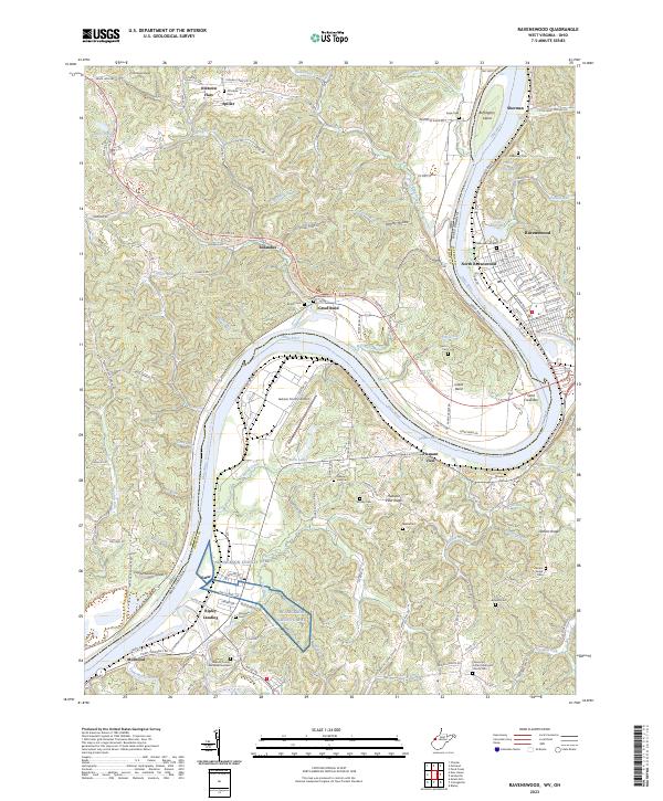 2023 Ravenswood2023 Print · USGSThe Ohio River valley near Ravenswood is shown here in the 2020s, revealing a landscape shaped by river commerce and ridge-top settlements. Genealogists can trace family landmarks and local burial grounds like Ottobine Cem, DeBussey Cem, and the Flatwoods United Methodist Church.
 - 2023 Map of Sandyville, 2023 Print
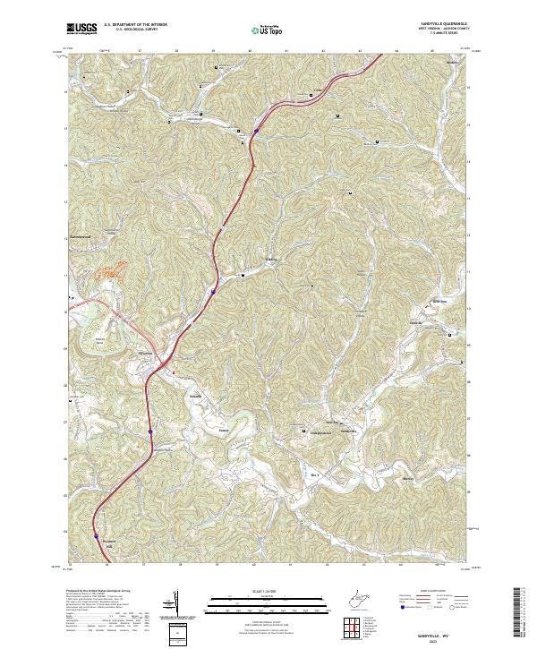 2023 Sandyville2023 Print · USGSJackson County's deeply-furrowed landscape is captured here in the early twenty-first century, showing the enduring rural network of Sandy Creek. Genealogists can locate family-named sites such as Nesselroad Cem, Staats Cem, and the Silverton-Red Bush School.
End of results
Showing maps 1-2 of 2
Top cities near Ravenswood
- Ripley historical maps
- Chester historical maps
- New Haven historical maps
- Syracuse historical maps
- Racine historical maps
- Hartford City historical maps
See more
Top neighborhoods of Ravenswood
Frequently asked questions
- What are the different types of historical maps available for Ravenswood?
- What is the oldest map of Ravenswood?
- Where can I purchase historical maps of Ravenswood for my home or office?
- Where can I download high-res historical maps of Ravenswood?
- Are there historical topographic maps available for Ravenswood?
- Is there historical aerial imagery available for Ravenswood?
- Where are historical maps of Ravenswood sourced from?