1960s Maps of Ravenswood, West Virginia
Explore 3 historic maps of Ravenswood from the 1960s. These maps offer a rare glimpse into what life looked like during the 1960s — showing old roads, neighborhoods, homes, and landmarks that have changed or disappeared over time.
Whether you're researching your family's past, planning a metal detecting trip, or studying how Ravenswood's landscape evolved across the 1960s, these high-resolution maps are a powerful tool for exploring the history of this region.
- Focus on a specific era: All maps on this page are from the 1960s, giving you a focused view of this time period.
- See what’s changed: Compare century-old streets, trails, and buildings to today's modern landscape using overlays and satellite layers.
- Research with precision: Use these maps for genealogy, historical research, land use analysis, or educational projects.
- View, download, or print: Maps are fully viewable online in high resolution, and can be downloaded or printed for your own records.
Start exploring Ravenswood's history through authentic maps from the 1960s. This is your window into the past.
Ravenswood, WV maps
(3)- 1960 Map of Ravenswood, 1963 Print
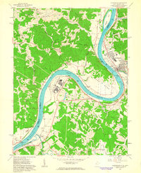 1960 Ravenswood1963 Print · USGSThe Ohio River sweeps through Jackson County at the dawn of the 1960s, showcasing a landscape of riverside industry and upland ridges. Researchers can locate family cemeteries like Wooley Cem, rural churches such as Bethlehem Ch, and the sprawling Ravenswood Works.5 unique versions available
 - 1960 Map of Sandyville, 1963 Print
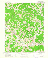 1960 Sandyville1963 Print · USGSSandyville and the surrounding West Virginia hollows are shown in the early sixties as a landscape of family farms and emerging energy production. Researchers can trace ancestral locations through named sites like Gilmore High Sch, the Derenburger Cem, and the Baltimore and Ohio rail line.3 unique versions available
 - 1961 Map of Charleston
 1961 Charleston1961 Print · USGSWest Virginia's capital region and the highlands to the east are shown in detail during the early sixties. Genealogists and historians can trace rail networks like the Baltimore and Ohio RR and find early state parks such as Watoga State Park.
End of results
Showing maps 1-3 of 3
Top cities near Ravenswood
- Ripley historical maps
- Chester historical maps
- New Haven historical maps
- Syracuse historical maps
- Racine historical maps
- Hartford City historical maps
See more
Top neighborhoods of Ravenswood
Frequently asked questions
- What are the different types of historical maps available for Ravenswood?
- What is the oldest map of Ravenswood?
- Where can I purchase historical maps of Ravenswood for my home or office?
- Where can I download high-res historical maps of Ravenswood?
- Are there historical topographic maps available for Ravenswood?
- Is there historical aerial imagery available for Ravenswood?
- Where are historical maps of Ravenswood sourced from?