1950s Maps of Charles Town, West Virginia
Explore 6 historic maps of Charles Town from the 1950s. These maps offer a rare glimpse into what life looked like during the 1950s — showing old roads, neighborhoods, homes, and landmarks that have changed or disappeared over time.
Whether you're researching your family's past, planning a metal detecting trip, or studying how Charles Town's landscape evolved across the 1950s, these high-resolution maps are a powerful tool for exploring the history of this region.
- Focus on a specific era: All maps on this page are from the 1950s, giving you a focused view of this time period.
- See what’s changed: Compare century-old streets, trails, and buildings to today's modern landscape using overlays and satellite layers.
- Research with precision: Use these maps for genealogy, historical research, land use analysis, or educational projects.
- View, download, or print: Maps are fully viewable online in high resolution, and can be downloaded or printed for your own records.
Start exploring Charles Town's history through authentic maps from the 1950s. This is your window into the past.
Charles Town, WV maps
(6)- 1953 Map of Charles Town
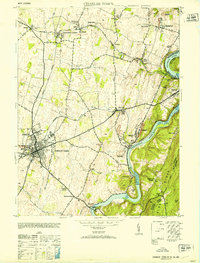 1953 Charles Town1953 Print · USGSJefferson County at mid-century centers on the rail junction of Charles Town and Ranson. Trace family roots at Zion Church or explore the industrial history of Millville and John Browns Cave.
 - 1954 Map of Baltimore
 1954 Baltimore1954 Print · USGSThe Mid-Atlantic region in the early fifties shows a landscape of growing suburban centers and heavy rail corridors. Trace mid-century transit networks and military landmarks from the Aberdeen Proving Ground to the Gettysburg National Military Park.
 - 1955 Map of Charles Town, 1956 Print
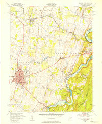 1955 Charles Town1956 Print · USGSThe West Virginia panhandle meets the Blue Ridge in the mid-1950s, where the great river forks converge. Researchers can trace the industrial corridor of the Baltimore and Ohio railroad or locate landmarks like John Browns Cave and Zion Church.2 unique versions available
 - 1955 Map of Middleway, 1957 Print
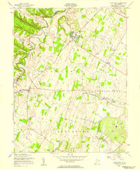 1955 Middleway1957 Print · USGSJefferson County's fertile valley floor is captured here in the mid-fifties, showing a landscape of established rail lines and historic crossroads. Genealogists and historians can locate the St Georges Chapel Ruins, the U S Fish Culture Station at Leetown, and the County Infirmary.3 unique versions available
 - 1956 Map of Baltimore
 1956 Baltimore1956 Print · USGSMid-century Maryland and Pennsylvania are captured here during a period of massive suburban and military growth across the Chesapeake region. Genealogists and historians can trace the rail corridors of the Baltimore & Ohio RR and locate landmarks like Fort McHenry or the Aberdeen Proving Ground.
 - 1957 Map of Baltimore, 1964 Print
 1957 Baltimore1964 Print · USGSMaryland and Southern Pennsylvania are shown during the mid-century expansion of the Baltimore-Washington corridor. Researchers can trace the extensive rail lines of the Baltimore & Ohio RR and locate sites like Fort Detrick and Gettysburg National Military Park.5 unique versions available
End of results
Showing maps 1-6 of 6
Top cities near Charles Town
- Martinsburg historical maps
- Purcellville historical maps
- Brunswick historical maps
- Ranson historical maps
- Berryville historical maps
- Boonsboro historical maps
See more
Top neighborhoods of Charles Town
Frequently asked questions
- What are the different types of historical maps available for Charles Town?
- What is the oldest map of Charles Town?
- Where can I purchase historical maps of Charles Town for my home or office?
- Where can I download high-res historical maps of Charles Town?
- Are there historical topographic maps available for Charles Town?
- Is there historical aerial imagery available for Charles Town?
- Where are historical maps of Charles Town sourced from?