1950s Maps of Jamestown, West Virginia
Explore 5 historic maps of Jamestown from the 1950s. These maps offer a rare glimpse into what life looked like during the 1950s — showing old roads, neighborhoods, homes, and landmarks that have changed or disappeared over time.
Whether you're researching your family's past, planning a metal detecting trip, or studying how Jamestown's landscape evolved across the 1950s, these high-resolution maps are a powerful tool for exploring the history of this region.
- Focus on a specific era: All maps on this page are from the 1950s, giving you a focused view of this time period.
- See what’s changed: Compare century-old streets, trails, and buildings to today's modern landscape using overlays and satellite layers.
- Research with precision: Use these maps for genealogy, historical research, land use analysis, or educational projects.
- View, download, or print: Maps are fully viewable online in high resolution, and can be downloaded or printed for your own records.
Start exploring Jamestown's history through authentic maps from the 1950s. This is your window into the past.
Jamestown, WV maps
(5)- 1953 Map of Berryville
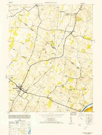 1953 Berryville1953 Print · USGSBerryville and the surrounding Shenandoah Valley come alive in this mid-century survey, capturing a cross-border community linked by major railroads. Genealogists can trace family connections through markers like Beulah Church, Feagans Mill, and small settlements like Rippon.
 - 1954 Map of Baltimore
 1954 Baltimore1954 Print · USGSThe Mid-Atlantic region in the early fifties shows a landscape of growing suburban centers and heavy rail corridors. Trace mid-century transit networks and military landmarks from the Aberdeen Proving Ground to the Gettysburg National Military Park.
 - 1955 Map of Berryville, 1956 Print
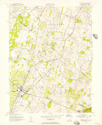 1955 Berryville1956 Print · USGSThe Shenandoah Valley during the mid-fifties remains an agricultural and spiritual landscape defined by its classic rail-and-river network. Genealogists and historians can trace family roots through Audley Farm, the Cistercian Monastery, and rural hamlets like Wickliffe or Rippon.
 - 1956 Map of Baltimore
 1956 Baltimore1956 Print · USGSMid-century Maryland and Pennsylvania are captured here during a period of massive suburban and military growth across the Chesapeake region. Genealogists and historians can trace the rail corridors of the Baltimore & Ohio RR and locate landmarks like Fort McHenry or the Aberdeen Proving Ground.
 - 1957 Map of Baltimore, 1964 Print
 1957 Baltimore1964 Print · USGSMaryland and Southern Pennsylvania are shown during the mid-century expansion of the Baltimore-Washington corridor. Researchers can trace the extensive rail lines of the Baltimore & Ohio RR and locate sites like Fort Detrick and Gettysburg National Military Park.5 unique versions available
End of results
Showing maps 1-5 of 5
Top cities near Jamestown
- Winchester historical maps
- Martinsburg historical maps
- Charles Town historical maps
- Ranson historical maps
- Berryville historical maps
- Shenandoah Farms historical maps
See more
Frequently asked questions
- What are the different types of historical maps available for Jamestown?
- What is the oldest map of Jamestown?
- Where can I purchase historical maps of Jamestown for my home or office?
- Where can I download high-res historical maps of Jamestown?
- Are there historical topographic maps available for Jamestown?
- Is there historical aerial imagery available for Jamestown?
- Where are historical maps of Jamestown sourced from?