1940s Maps of Middleway, West Virginia
Explore 3 historic maps of Middleway from the 1940s. These maps offer a rare glimpse into what life looked like during the 1940s — showing old roads, neighborhoods, homes, and landmarks that have changed or disappeared over time.
Whether you're researching your family's past, planning a metal detecting trip, or studying how Middleway's landscape evolved across the 1940s, these high-resolution maps are a powerful tool for exploring the history of this region.
- Focus on a specific era: All maps on this page are from the 1940s, giving you a focused view of this time period.
- See what’s changed: Compare century-old streets, trails, and buildings to today's modern landscape using overlays and satellite layers.
- Research with precision: Use these maps for genealogy, historical research, land use analysis, or educational projects.
- View, download, or print: Maps are fully viewable online in high resolution, and can be downloaded or printed for your own records.
Start exploring Middleway's history through authentic maps from the 1940s. This is your window into the past.
Middleway, WV maps
(3)- 1944 Map of Middleway
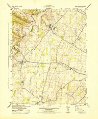 1944 Middleway1944 Print · USGSJefferson County at the height of the Second World War was a network of rural hamlets and rail lines. Genealogists and historians can trace family-named sites from Lower Johnsontown to Summit Point and the U S Fish Hatchery.
 - 1944 Map of Martinsburg, 1964 Print
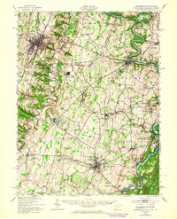 1944 Martinsburg1964 Print · USGSThe West Virginia Panhandle is captured during the mid-1940s, revealing a landscape of vital rail junctions and Potomac River crossings. Genealogists and historians can trace the foundations of Shepherdstown and Martinsburg, alongside landmarks like Martin Chapel and the Newton D Baker General Hospital.
 - 1948 Map of Baltimore
 1948 Baltimore1948 Print · USGSMaryland and Pennsylvania crossroads are captured in the late 1940s, showing a landscape defined by historic rail lines and major military installations. Genealogists can trace family connections in Gettysburg, Westminster, and near the U.S. Naval Academy in Annapolis.2 unique versions available
End of results
Showing maps 1-3 of 3
Top cities near Middleway
- Winchester historical maps
- Martinsburg historical maps
- Charles Town historical maps
- Ranson historical maps
- Berryville historical maps
- Shannondale historical maps
See more
Frequently asked questions
- What are the different types of historical maps available for Middleway?
- What is the oldest map of Middleway?
- Where can I purchase historical maps of Middleway for my home or office?
- Where can I download high-res historical maps of Middleway?
- Are there historical topographic maps available for Middleway?
- Is there historical aerial imagery available for Middleway?
- Where are historical maps of Middleway sourced from?