1970s Maps of Morgantown, West Virginia
Explore 3 historic maps of Morgantown from the 1970s. These maps offer a rare glimpse into what life looked like during the 1970s — showing old roads, neighborhoods, homes, and landmarks that have changed or disappeared over time.
Whether you're researching your family's past, planning a metal detecting trip, or studying how Morgantown's landscape evolved across the 1970s, these high-resolution maps are a powerful tool for exploring the history of this region.
- Focus on a specific era: All maps on this page are from the 1970s, giving you a focused view of this time period.
- See what’s changed: Compare century-old streets, trails, and buildings to today's modern landscape using overlays and satellite layers.
- Research with precision: Use these maps for genealogy, historical research, land use analysis, or educational projects.
- View, download, or print: Maps are fully viewable online in high resolution, and can be downloaded or printed for your own records.
Start exploring Morgantown's history through authentic maps from the 1970s. This is your window into the past.
Morgantown, WV maps
(3)- 1976 Map of Morgantown South, 1979 Print
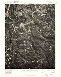 1976 Morgantown South1979 Print · USGSMonongalia County in the mid-seventies shows the expanding suburban footprint of Morgantown as it reaches into the Appalachian hills. Genealogists and researchers can trace local landmarks like Brookhaven, Dellslow, and the winding Monongahela River.
 - 1976 Map of Morgantown North, 1979 Print
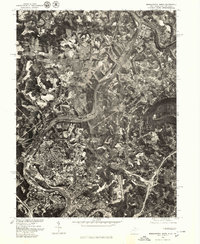 1976 Morgantown North1979 Print · USGSThe Monongahela River valley appears in sharp aerial detail in the mid-1970s, showcasing the industrial and residential heart of West Virginia’s northern border. Researchers can trace the development of Morgantown and Westover or locate more rural settlements like Maidsville and Point Marion.
 - 1979 Map of Morgantown, 1983 Print
 1979 Morgantown1983 Print · USGSThe northern Appalachian borderlands are captured here in the late seventies, showing the tri-state area of West Virginia, Pennsylvania, and Maryland. Genealogists and historians can trace the Mason and Dixon Line through mountain settlements like Markleysburg and across the Youghiogheny River Lake.
End of results
Showing maps 1-3 of 3
Top cities near Morgantown
- Fairmont historical maps
- Westover historical maps
- Masontown historical maps
- Pleasant Valley historical maps
- Springhill Township historical maps
- Dunkard Township historical maps
See more
Top neighborhoods of Morgantown
- Evansdale historical maps
- Fieldcrest historical maps
- South Hills historical maps
- West Sabraton historical maps
- South Park historical maps
- Suncrest historical maps
See more
Frequently asked questions
- What are the different types of historical maps available for Morgantown?
- What is the oldest map of Morgantown?
- Where can I purchase historical maps of Morgantown for my home or office?
- Where can I download high-res historical maps of Morgantown?
- Are there historical topographic maps available for Morgantown?
- Is there historical aerial imagery available for Morgantown?
- Where are historical maps of Morgantown sourced from?