1910s Maps of Mason Branch, West Virginia
Explore 2 historic maps of Mason Branch from the 1910s. These maps offer a rare glimpse into what life looked like during the 1910s — showing old roads, neighborhoods, homes, and landmarks that have changed or disappeared over time.
Whether you're researching your family's past, planning a metal detecting trip, or studying how Mason Branch's landscape evolved across the 1910s, these high-resolution maps are a powerful tool for exploring the history of this region.
- Focus on a specific era: All maps on this page are from the 1910s, giving you a focused view of this time period.
- See what’s changed: Compare century-old streets, trails, and buildings to today's modern landscape using overlays and satellite layers.
- Research with precision: Use these maps for genealogy, historical research, land use analysis, or educational projects.
- View, download, or print: Maps are fully viewable online in high resolution, and can be downloaded or printed for your own records.
Start exploring Mason Branch's history through authentic maps from the 1910s. This is your window into the past.
Mason Branch, WV maps
(2)- 1914 Map of Winona
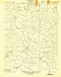 1914 Winona1914 Print · USGSCentral West Virginia's rugged highlands are captured here just as the timber industry began to reshape the landscape. Local historians can trace early mountain life through dozens of named schools like Bean School and crossings such as Carnefix Ferry and Raders Ford.2 unique versions available
 - 1916 Map of Winona
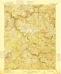 1916 Winona1916 Print · USGSNicholas and Fayette Counties are documented here before the mid-century industrial shifts, showing a world of river crossings and mountain schools. Genealogists can trace family footprints at Carnifex Ferry, Withrows Mill, and dozens of rural sites like Nutterville.3 unique versions available
End of results
Showing maps 1-2 of 2
Top cities near Mason Branch
- Oak Hill historical maps
- Summersville historical maps
- Fayetteville historical maps
- Ansted historical maps
- Gauley Bridge historical maps
- Clay historical maps
See more
Frequently asked questions
- What are the different types of historical maps available for Mason Branch?
- What is the oldest map of Mason Branch?
- Where can I purchase historical maps of Mason Branch for my home or office?
- Where can I download high-res historical maps of Mason Branch?
- Are there historical topographic maps available for Mason Branch?
- Is there historical aerial imagery available for Mason Branch?
- Where are historical maps of Mason Branch sourced from?