1900s (20th Century) Maps of Pocahontas County, West Virginia
Explore 94 historic maps of Pocahontas County from the 1900s (20th Century). These maps offer a rare glimpse into what life looked like during the 1900s — showing old roads, neighborhoods, homes, and landmarks that have changed or disappeared over time.
Whether you're researching your family's past, planning a metal detecting trip, or studying how Pocahontas County's landscape evolved across the 1900s, these high-resolution maps are a powerful tool for exploring the history of this region.
- Focus on a specific era: All maps on this page are from the 1900s, giving you a focused view of this time period.
- See what’s changed: Compare century-old streets, trails, and buildings to today's modern landscape using overlays and satellite layers.
- Research with precision: Use these maps for genealogy, historical research, land use analysis, or educational projects.
- View, download, or print: Maps are fully viewable online in high resolution, and can be downloaded or printed for your own records.
Start exploring Pocahontas County's history through authentic maps from the 1900s. This is your window into the past.
Pocahontas County, WV maps
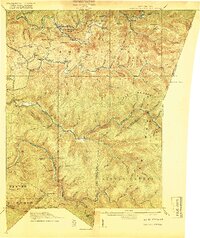
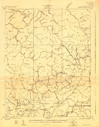
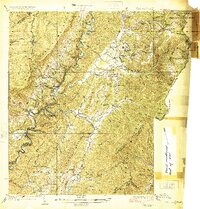
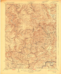
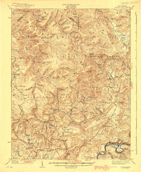
(94)- 1901 Map of Monterey, 1905 Print
 1901 Monterey1905 Print · USGSThe high Allegheny ridges of Highland and Bath Counties are shown at the turn of the century when isolated valley settlements were linked by winding mountain gaps. Genealogists can trace early homesteads and commerce centers like Cleeks Mills, Mountaingrove, and New Hampden.8 unique versions available
 - 1915 Map of Webster Springs
 1915 Webster Springs1915 Print · USGSWebster County at the start of the Great War was a landscape of high ridges and deep river valleys. Genealogists and historians can trace old homesteads and mountain schoolhouses like Redoak School and Cherry Falls School along the banks of the Elk River.3 unique versions available
 - 1918 Map of Webster Springs
 1918 Webster Springs1918 Print · USGSThe West Virginia highlands are shown in detail during the height of the early twentieth-century timber boom. Researchers can trace historic transport lines like the Virginia and West Virginia RR and locate early community centers like Webster Springs (Addison) and St. Michael School.4 unique versions available
 - 1922 Map of Spruce Knob
 1922 Spruce Knob1922 Print · USGSThe Potomac Highlands are seen here in the early 1920s, a period defined by small mountain gaps and high-altitude settlements. Researchers can trace rural life through dozens of sites like Osceola Po, Winterburn Station, and the isolated Ridge Church.3 unique versions available
 - 1922 Map of Cass
 1922 Cass1922 Print · USGSThe West Virginia highlands are shown here in the 1920s as a bustling corridor of mountain rail and timber industry. Genealogists can trace family roots through numerous country landmarks like Wanless Church, McLaughlin School, and the remote rail town of Spruce.4 unique versions available
 - 1922 Map of Durbin
 1922 Durbin1922 Print · USGSHigh mountain passes and rail hubs near the Pocahontas county line are captured here in the early twenties. Genealogists and historians can trace family locations through numerous rural schools like Riffle Creek School and the remote Cheat Bridge settlement.4 unique versions available
 - 1923 Map of Lobelia
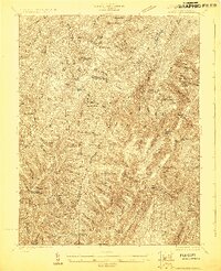
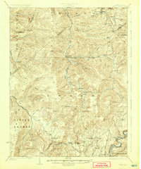
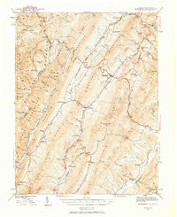
 1923 Lobelia1923 Print · USGSGreenbrier and Pocahontas Counties are shown in the early 1920s as mountain farming and timber harvesting shaped the landscape. Researchers can trace dozens of rural institutions, from Ellis Chapel and Band of Hope Church to remote schools like West Droop School.2 unique versions available
 - 1923 Map of Marlinton
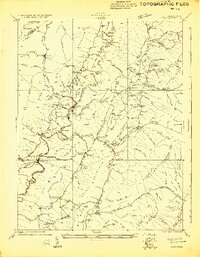
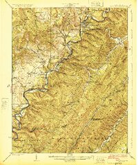
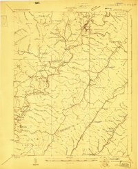 1923 Marlinton1923 Print · USGSPocahontas County at the start of the twenties shows a landscape defined by the timber industry and the winding Greenbrier River. Genealogists can trace family names through dozens of rural landmarks, including Grimes School, Hefners School, and May Chapel.6 unique versions available
 - 1923 Map of Warm Springs
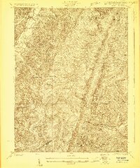
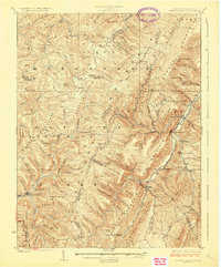
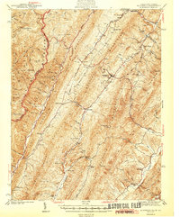
 1923 Warm Springs1923 Print · USGSThe mountain border between West Virginia and Virginia comes into focus in the early 1920s, revealing a landscape of remote mountain gaps and hollows. Researchers can locate numerous local landmarks like Minnehaha Springs, Mt Carmel Church, and the Circle Hill School.2 unique versions available
 - 1923 Map of Mingo
 1923 Mingo1923 Print · USGSThe West Virginia highlands are shown in detail during the early twenties, highlighting the region's timber-driven economy and remote mountain enclaves. Genealogists can locate family-named schools and churches like Hannah School, Marys Chapel, and West Union Church along the winding Lumber RR.2 unique versions available
 - 1924 Map of Cass
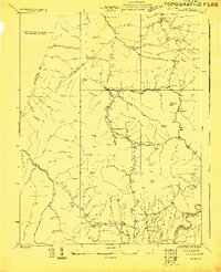
 1924 Cass1924 Print · USGSPocahontas County was a mountain landscape of timber and rail in the early 1920s, dominated by the Greenbrier River valley. Genealogists can locate family landmarks like Dilleys Mill, Hevener Church, and numerous schools including the Pine Grove School.3 unique versions available
 - 1924 Map of Durbin
 1924 Durbin1924 Print · USGSRandolph and Pocahontas counties appear here in the early twenties, during a period of heavy timber railroading and mountain settlement. Researchers can locate vanished landmarks like Burner Settlement, the high crossing at Cheat Bridge, and numerous rural schools like Lee Bell School.4 unique versions available
 - 1924 Map of Spruce Knob
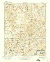
 1924 Spruce Knob1924 Print · USGSThe Allegheny high country comes alive in the mid-twenties, centered on the heights of Spruce Knob and the North Fork River. Genealogists can trace family footprints at Osceola PO, Rexrode, and numerous mountain schools like Stark School.2 unique versions available
 - 1925 Map of Mingo
 1925 Mingo1925 Print · USGSPocahontas County at the headwaters of the Greenbrier is seen here in the mid-twenties, a landscape of high ridges and isolated mountain valleys. Researchers can locate dozens of early rural schools like Yewglade School and churches such as Marys Chapel or Poage Chapel.4 unique versions available
 - 1925 Map of Marlinton
 1925 Marlinton1925 Print · USGSMarlinton and the Greenbrier River valley are captured in the mid-twenties, showing a landscape defined by the Chesapeake and Ohio railroad. Genealogy researchers can locate family landmarks like Locust PO, Trinity Church, and many rural schools.3 unique versions available
 - 1925 Map of Lobelia
 1925 Lobelia1925 Print · USGSThe mountains and wetlands of Greenbrier County are captured here in the mid-1920s, showing a landscape of high ridges and rural valley settlements. Trace old family sites and mountain outposts like Lobelia, Trout Valley, and the Cranberry Glades.2 unique versions available
 - 1926 Map of Warm Springs
 1926 Warm Springs1926 Print · USGSThe West Virginia and Virginia borderlands come alive in this mid-1920s survey of the high Alleghenies. Researchers can trace rural life through landmarks like Minnehaha Springs, Westminster Church, and schools at Rimel and Sunset.5 unique versions available
 - 1930 Map of Mountain Grove
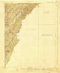
 1930 Mountain Grove1930 Print · USGSThe Virginia and West Virginia borderlands in the late 1920s are captured here during a time of isolated mountain settlements and river-bottom farming. Genealogists can trace family footprints through the numerous named hollows and crossings like Mcclintic Bridge, Mountain Grove, and Mooretown.
 - 1933 Map of Mountain Grove
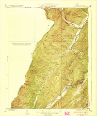 1933 Mountain Grove1933 Print · USGSBath County's high ridges and river valleys are captured here in the early 1930s as a network of mountain hollows and small settlements. Genealogists and local historians can locate Mooretown, trace the namesake Mountain Grove, and find the Mailbox Sch and Eden Ch.3 unique versions available
 - 1935 Map of Lobelia, 1959 Print
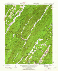
 1935 Lobelia1959 Print · USGSThe Greenbrier County backcountry is shown in the mid-1930s, just as the regional forest service infrastructure was expanding. Genealogists and historians can trace numerous rural schoolhouses and churches, from Beulah Church to the Baldwin School and the remote Trout PO.2 unique versions available
 - 1939 Map of Lobelia
 1939 Lobelia1939 Print · USGSGreenbrier and Pocahontas counties appear here in the years before the war, characterized by high mountain plateaus and a dense network of rural schoolhouses. Researchers can trace family roots through sites like Rockcamp Cem, Bethel Church, and the Trout Valley Trout Post Office.2 unique versions available
 - 1941 Map of Monterey, 1963 Print
 1941 Monterey1963 Print · USGSHighland County at the start of the 1940s reveals a network of high-valley settlements and strategic turnpikes. Trace the locations of early schools and churches like Strait Creek School and Union Chapel near the South Branch of the Potomac.2 unique versions available
 - 1944 Map of Monterey
 1944 Monterey1944 Print · USGSHighland County at the height of the Second World War remains a land of high ridges and isolated mountain valleys. Genealogists can trace family footprints across Bluegrass Valley and locate landmarks like Hamilton Chapel, Possum Trot, and the Strait Creek Sch.2 unique versions available
 - 1946 Map of Warm Springs, 1962 Print
 1946 Warm Springs1962 Print · USGSBath County and the Allegheny borderlands are captured here in the mid-1940s, showing the early infrastructure of this resort and timber region. Researchers can trace family sites at Mountain Grove, rural pulpits like Mt Hope Ch, and the crossing at Moclintic Bridge.2 unique versions available
 - 1949 Map of Charlottesville
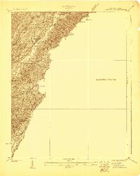
 1949 Charlottesville1949 Print · USGSThe Shenandoah Valley and Blue Ridge appear in the late 1940s as a thriving corridor of rail and river commerce. Researchers can trace the mid-century footprints of Harrisonburg, Staunton, and Culpeper alongside the historic routes of the Southern Railway.2 unique versions available
Showing maps 1-25 of 94
Top cities of Pocahontas County
Frequently asked questions
- What are the different types of historical maps available for Pocahontas County?
- What is the oldest map of Pocahontas County?
- Where can I purchase historical maps of Pocahontas County for my home or office?
- Where can I download high-res historical maps of Pocahontas County?
- Are there historical topographic maps available for Pocahontas County?
- Is there historical aerial imagery available for Pocahontas County?
- Where are historical maps of Pocahontas County sourced from?