1960s Maps of Pocahontas County, West Virginia
Explore 12 historic maps of Pocahontas County from the 1960s. These maps offer a rare glimpse into what life looked like during the 1960s — showing old roads, neighborhoods, homes, and landmarks that have changed or disappeared over time.
Whether you're researching your family's past, planning a metal detecting trip, or studying how Pocahontas County's landscape evolved across the 1960s, these high-resolution maps are a powerful tool for exploring the history of this region.
- Focus on a specific era: All maps on this page are from the 1960s, giving you a focused view of this time period.
- See what’s changed: Compare century-old streets, trails, and buildings to today's modern landscape using overlays and satellite layers.
- Research with precision: Use these maps for genealogy, historical research, land use analysis, or educational projects.
- View, download, or print: Maps are fully viewable online in high resolution, and can be downloaded or printed for your own records.
Start exploring Pocahontas County's history through authentic maps from the 1960s. This is your window into the past.
Pocahontas County, WV maps
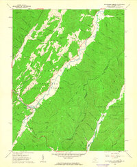
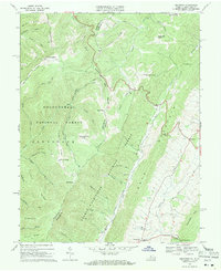
(12)- 1960 Map of Green Bank, 1961 Print
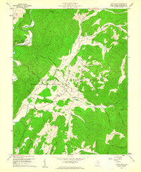 1960 Green Bank1961 Print · USGSPocahontas County at the dawn of the space age reveals a unique juxtaposition of traditional mountain life and cutting-edge science. Genealogists and historians can trace family-named sites like Asbury Knob or Galford alongside the Monongahela National Radio Astronomy Observatory and its Telescope installations.3 unique versions available
 - 1961 Map of Charleston
 1961 Charleston1961 Print · USGSWest Virginia's capital region and the highlands to the east are shown in detail during the early sixties. Genealogists and historians can trace rail networks like the Baltimore and Ohio RR and find early state parks such as Watoga State Park.
 - 1961 Map of Paddy Knob, 1964 Print
 1961 Paddy Knob1964 Print · USGSThe West Virginia and Virginia borderlands come to life in the early sixties, showing the remote high-country terrain of Pocahontas County. Researchers can find numerous family burial sites like Shinaberry Cem, the mountain chapel of Wesley Chapel, and the small settlement at Frost.2 unique versions available
 - 1961 Map of Mountain Grove, 1964 Print
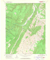
 1961 Mountain Grove1964 Print · USGSThe Virginia and West Virginia borderlands in the early 1960s feature a network of high ridges and isolated hollows. Genealogists and historians can trace family-named sites like Mooretown and Gochran Creek Ch, or locate the Chesapeake and Ohio line near Bacova Junction.2 unique versions available
 - 1961 Map of Sunrise, 1981 Print
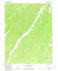 1961 Sunrise1981 Print · USGSThe Virginia and West Virginia borderlands appear here in the early sixties, centered on the high ridges and deep valleys of the national forests. Researchers can locate remote family landmarks like Doyle Cem, Zion Hill Ch, and the small settlement at Sunrise.2 unique versions available
 - 1962 Map of Minnehaha Springs, 1963 Print
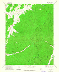
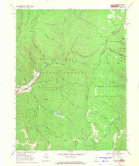
 1962 Minnehaha Springs1963 Print · USGSThe mountain valleys of Pocahontas County come into focus in the early sixties, showing the intersection of two national forests. Genealogists can locate family landmarks such as Shinaberry Cem, Dourif Airport, and Mt Carmel Ch along the winding Knapp Creek.3 unique versions available
 - 1966 Map of Bergoo, 1970 Print
 1966 Bergoo1970 Print · USGSThe coal and timber country of Webster County is shown here in the mid-1960s, a landscape defined by deep valleys and high-ridge extraction. Researchers can trace the rail networks of the Baltimore and Ohio through Jerryville and locate specific sites like Pleasant Grove Ch.2 unique versions available
 - 1967 Map of Webster Springs SE, 1970 Print
 1967 Webster Springs SE1970 Print · USGSThe high wilderness of the Allegheny Mountains in the late sixties is mapped here in detail across the Webster and Pocahontas county line. Hikers and historians can trace the remote waterways of Hell For Certain Branch and find early backcountry landmarks like the Tumbling Rock Camping Shelter.3 unique versions available
 - 1969 Map of Mustoe, 1970 Print
 1969 Mustoe1970 Print · USGSHighland County's mountain gaps and river valleys are captured here in the late sixties. Genealogists can trace family names and sites through several country churches and cemeteries, such as Wesley Chapel, Fairview Cem, and the settlement at Valley Center.3 unique versions available
 - 1969 Map of Hightown, 1971 Print
 1969 Hightown1971 Print · USGSThe high ridges of Highland County are captured in the late sixties, where the Virginia and West Virginia border meets. Genealogists can locate small community cemeteries, Pisgah Ch, and the high-elevation settlements of Hightown and Meadowdale.3 unique versions available
 - 1969 Map of Snowy Mountain, 1971 Print
 1969 Snowy Mountain1971 Print · USGSThe West Virginia and Virginia borderlands were still characterized by remote mountain settlements and national forest tracts in the late sixties. Genealogists and hikers can trace the paths between Hardscrabble, Dry Run Ch, and the high peak of Snowy Mountain.2 unique versions available
 - 1969 Map of Thornwood, 1971 Print
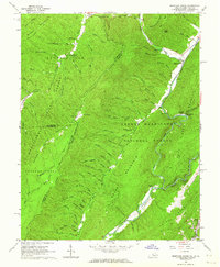
 1969 Thornwood1971 Print · USGSThe West Virginia and Virginia borderlands come into focus in the late sixties, where the Greenbrier River headwaters meet national forest lands. Local historians can locate Thornwood, the Buffalo Fork Dam, and family landmarks like Rambottom or the Cem near Circleville.2 unique versions available
End of results
Showing maps 1-12 of 12
Top cities of Pocahontas County
Frequently asked questions
- What are the different types of historical maps available for Pocahontas County?
- What is the oldest map of Pocahontas County?
- Where can I purchase historical maps of Pocahontas County for my home or office?
- Where can I download high-res historical maps of Pocahontas County?
- Are there historical topographic maps available for Pocahontas County?
- Is there historical aerial imagery available for Pocahontas County?
- Where are historical maps of Pocahontas County sourced from?