1970s Maps of Putnam County, West Virginia
Explore 6 historic maps of Putnam County from the 1970s. These maps offer a rare glimpse into what life looked like during the 1970s — showing old roads, neighborhoods, homes, and landmarks that have changed or disappeared over time.
Whether you're researching your family's past, planning a metal detecting trip, or studying how Putnam County's landscape evolved across the 1970s, these high-resolution maps are a powerful tool for exploring the history of this region.
- Focus on a specific era: All maps on this page are from the 1970s, giving you a focused view of this time period.
- See what’s changed: Compare century-old streets, trails, and buildings to today's modern landscape using overlays and satellite layers.
- Research with precision: Use these maps for genealogy, historical research, land use analysis, or educational projects.
- View, download, or print: Maps are fully viewable online in high resolution, and can be downloaded or printed for your own records.
Start exploring Putnam County's history through authentic maps from the 1970s. This is your window into the past.
Putnam County, WV maps
(6)- 1972 Map of Hurricane, 1973 Print
 1972 Hurricane1973 Print · USGSThe West Virginia communities of Culloden and Hurricane are shown during a period of steady growth in the early seventies. Genealogists and local historians can locate many small landmarks like Bedford Chapel, Valley View Cem, and the Mountain State Christian Sch.2 unique versions available
 - 1976 Map of Saint Albans, 1980 Print
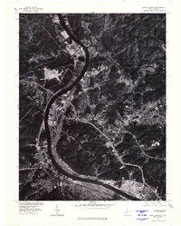 1976 Saint Albans1980 Print · USGSThe Kanawha River valley's industrial and residential layout is captured here in the mid-seventies via detailed orthophotography. Researchers can examine the dense footprints of Saint Albans, Nitro, and the riverside community of Poca.
 - 1976 Map of Bancroft, 1980 Print
 1976 Bancroft1980 Print · USGSThe Kanawha River valley in the mid-seventies shows a landscape shaped by river commerce and steep ridges. Trace the local settlement patterns of Bancroft and Hometown or locate the upland clearings around Confidence and Heizer.
 - 1977 Map of Robertsburg, 1979 Print
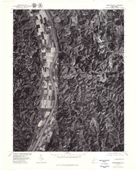 1977 Robertsburg1979 Print · USGSAlong the Kanawha River in the late seventies, this aerial survey documents a landscape of productive bottomland farms and wooded ridges. Genealogists and local historians can pinpoint specific rural homesteads in Robertsburg, Southside, and Leon.
 - 1977 Map of Pocatalico, 1980 Print
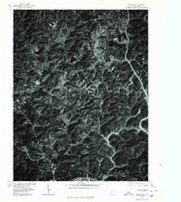 1977 Pocatalico1980 Print · USGSWest Virginia's river valleys and wooded ridges are seen from above in the late seventies. Family historians and land researchers can trace property lines and settlement footprints in Pocatalico, Guthrie, and along the Pocatalico River.
 - 1977 Map of Scott Depot, 1980 Print
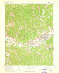
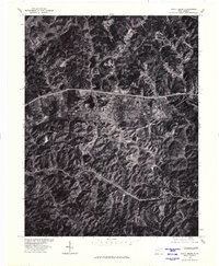 1977 Scott Depot1980 Print · USGSPutnam County's late-century development is visible here as modern highways began to reshape these traditional West Virginia valleys. Genealogists and historians can trace residential growth and land use around Scott Depot, Teays, and the high point of Hickory Knob.
End of results
Showing maps 1-6 of 6
Top cities of Putnam County
- Teays Valley historical maps
- Hurricane historical maps
- Winfield historical maps
- Eleanor historical maps
- Buffalo historical maps
- Poca historical maps
See more
Frequently asked questions
- What are the different types of historical maps available for Putnam County?
- What is the oldest map of Putnam County?
- Where can I purchase historical maps of Putnam County for my home or office?
- Where can I download high-res historical maps of Putnam County?
- Are there historical topographic maps available for Putnam County?
- Is there historical aerial imagery available for Putnam County?
- Where are historical maps of Putnam County sourced from?