1960s Maps of Sophia, West Virginia
Explore 3 historic maps of Sophia from the 1960s. These maps offer a rare glimpse into what life looked like during the 1960s — showing old roads, neighborhoods, homes, and landmarks that have changed or disappeared over time.
Whether you're researching your family's past, planning a metal detecting trip, or studying how Sophia's landscape evolved across the 1960s, these high-resolution maps are a powerful tool for exploring the history of this region.
- Focus on a specific era: All maps on this page are from the 1960s, giving you a focused view of this time period.
- See what’s changed: Compare century-old streets, trails, and buildings to today's modern landscape using overlays and satellite layers.
- Research with precision: Use these maps for genealogy, historical research, land use analysis, or educational projects.
- View, download, or print: Maps are fully viewable online in high resolution, and can be downloaded or printed for your own records.
Start exploring Sophia's history through authentic maps from the 1960s. This is your window into the past.
Sophia, WV maps
(3)- 1961 Map of Bluefield
 1961 Bluefield1961 Print · USGSThe coalfields and mountain ridges of southern West Virginia and southwest Virginia are captured in the early sixties. Genealogists can trace family ties through rail-linked towns like Princeton and Richlands or along the shores of Bluestone Reservoir.
 - 1967 Map of Lester, 1970 Print
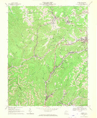 1967 Lester1970 Print · USGSRaleigh County coal country is captured here in the late sixties, showing the peak rail-and-mine network of the Slab Fork District. Researchers can trace the industrial footprint of Stotesbury, Tams, and Helen along the Winding Gulf rail lines.2 unique versions available
 - 1968 Map of Crab Orchard, 1972 Print
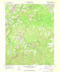 1968 Crab Orchard1972 Print · USGSIn the late 1960s, the coal country of Raleigh County was a bustle of rail lines and ridge-top communities. Genealogists and industrial historians can trace the foundations of Coal City, Winding Gulf, and Lillybrook alongside the Norfolk and Western rail lines.2 unique versions available
End of results
Showing maps 1-3 of 3
Top cities near Sophia
- Beckley historical maps
- Mullens historical maps
- Mount Hope historical maps
- Mabscott historical maps
- Bud historical maps
- Corinne historical maps
See more
Frequently asked questions
- What are the different types of historical maps available for Sophia?
- What is the oldest map of Sophia?
- Where can I purchase historical maps of Sophia for my home or office?
- Where can I download high-res historical maps of Sophia?
- Are there historical topographic maps available for Sophia?
- Is there historical aerial imagery available for Sophia?
- Where are historical maps of Sophia sourced from?