1900-1909 Maps of Buckhannon, West Virginia
Explore 2 historic maps of Buckhannon from 1900-1909. These maps offer a rare glimpse into what life looked like during the 1900s — showing old roads, neighborhoods, homes, and landmarks that have changed or disappeared over time.
Whether you're researching your family's past, planning a metal detecting trip, or studying how Buckhannon's landscape evolved across the 1900s, these high-resolution maps are a powerful tool for exploring the history of this region.
- Focus on a specific era: All maps on this page are from the 1900s, giving you a focused view of this time period.
- See what’s changed: Compare century-old streets, trails, and buildings to today's modern landscape using overlays and satellite layers.
- Research with precision: Use these maps for genealogy, historical research, land use analysis, or educational projects.
- View, download, or print: Maps are fully viewable online in high resolution, and can be downloaded or printed for your own records.
Start exploring Buckhannon's history through authentic maps from the 1900s. This is your window into the past.
Buckhannon, WV maps
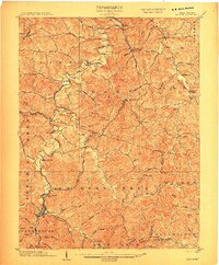
(2)- 1904 Map of Philippi
 1904 Philippi1904 Print · USGSBarbour and Upshur counties are shown during a period of coal-driven growth and rural stability just after the turn of the century. Trace the early industrial footprints of Berryburg and Century, or locate family landmarks like Peter's Mill and the Burnersville Volga P.O..2 unique versions available
 - 1904 Map of Weston
 1904 Weston1904 Print · USGSWest Virginia's Lewis and Harrison counties at the start of the century show a region shaped by coal and steam. Genealogists and historians can trace family roots through early settlements like Jane Lew, identify operations at Lynch Mines, and locate the Dovener P.O. Dean.2 unique versions available
End of results
Showing maps 1-2 of 2
Top cities near Buckhannon
- Weston historical maps
- Philippi historical maps
- West Milford historical maps
- Lost Creek historical maps
- Jane Lew historical maps
- Bentley historical maps
Top neighborhoods of Buckhannon
Frequently asked questions
- What are the different types of historical maps available for Buckhannon?
- What is the oldest map of Buckhannon?
- Where can I purchase historical maps of Buckhannon for my home or office?
- Where can I download high-res historical maps of Buckhannon?
- Are there historical topographic maps available for Buckhannon?
- Is there historical aerial imagery available for Buckhannon?
- Where are historical maps of Buckhannon sourced from?