1980s Maps of Buckhannon, West Virginia
Explore 3 historic maps of Buckhannon from the 1980s. These maps offer a rare glimpse into what life looked like during the 1980s — showing old roads, neighborhoods, homes, and landmarks that have changed or disappeared over time.
Whether you're researching your family's past, planning a metal detecting trip, or studying how Buckhannon's landscape evolved across the 1980s, these high-resolution maps are a powerful tool for exploring the history of this region.
- Focus on a specific era: All maps on this page are from the 1980s, giving you a focused view of this time period.
- See what’s changed: Compare century-old streets, trails, and buildings to today's modern landscape using overlays and satellite layers.
- Research with precision: Use these maps for genealogy, historical research, land use analysis, or educational projects.
- View, download, or print: Maps are fully viewable online in high resolution, and can be downloaded or printed for your own records.
Start exploring Buckhannon's history through authentic maps from the 1980s. This is your window into the past.
Buckhannon, WV maps
(3)- 1981 Map of Sutton, 1982 Print
 1981 Sutton1982 Print · USGSCentral West Virginia's mountain ridges and river valleys are captured here during the early eighties, as Interstate 79 began to modernize the region. Trace old rail lines like the Western Maryland Railway or explore the terrain around Sutton Lake and Helvetia.
 - 1982 Map of Clarksburg, 1983 Print
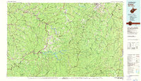
 1982 Clarksburg1983 Print · USGSNorth Central West Virginia in the early eighties reveals a landscape deeply connected to its coal and gas resources. Genealogists and researchers can trace family landmarks and historical settlements from Clarksburg to Buckhannon, or locate sites like Quiet Dell and Watters Smith Memorial State Park.
 - 1988 Map of Clarksburg, 1989 Print
 1988 Clarksburg1989 Print · USGSThe central Appalachians are documented in detail during the late eighties, showing the industrial and river-based economies of West Virginia, Ohio, and Pennsylvania. Researchers can trace historic rail routes like the B & O RR and locate river towns from St Marys to Parkersburg.
End of results
Showing maps 1-3 of 3
Top cities near Buckhannon
- Weston historical maps
- Philippi historical maps
- West Milford historical maps
- Lost Creek historical maps
- Jane Lew historical maps
- Bentley historical maps
Top neighborhoods of Buckhannon
Frequently asked questions
- What are the different types of historical maps available for Buckhannon?
- What is the oldest map of Buckhannon?
- Where can I purchase historical maps of Buckhannon for my home or office?
- Where can I download high-res historical maps of Buckhannon?
- Are there historical topographic maps available for Buckhannon?
- Is there historical aerial imagery available for Buckhannon?
- Where are historical maps of Buckhannon sourced from?