1950s Maps of Wood County, West Virginia
Explore 8 historic maps of Wood County from the 1950s. These maps offer a rare glimpse into what life looked like during the 1950s — showing old roads, neighborhoods, homes, and landmarks that have changed or disappeared over time.
Whether you're researching your family's past, planning a metal detecting trip, or studying how Wood County's landscape evolved across the 1950s, these high-resolution maps are a powerful tool for exploring the history of this region.
- Focus on a specific era: All maps on this page are from the 1950s, giving you a focused view of this time period.
- See what’s changed: Compare century-old streets, trails, and buildings to today's modern landscape using overlays and satellite layers.
- Research with precision: Use these maps for genealogy, historical research, land use analysis, or educational projects.
- View, download, or print: Maps are fully viewable online in high resolution, and can be downloaded or printed for your own records.
Start exploring Wood County's history through authentic maps from the 1950s. This is your window into the past.
Wood County, WV maps
(8)- 1956 Map of Clarksburg, 1966 Print
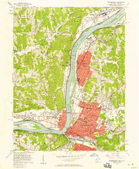
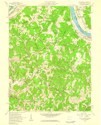
 1956 Clarksburg1966 Print · USGSThe Ohio River valley and the industrial heart of West Virginia are seen here in the mid-1950s as rail and river commerce thrived. Researchers can trace historic transport lines like the Baltimore and Ohio RR and locate ancestral homes in Clarksburg, Moundsville, or Parkersburg.2 unique versions available
 - 1957 Map of Parkersburg, 1958 Print
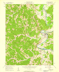
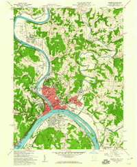
 1957 Parkersburg1958 Print · USGSThe Ohio River valley at the height of its mid-century industrial era comes to life on this 1957 survey of Parkersburg and Belpre. Genealogists can locate family sites at Mt Olivet Cemetery, Cutler Chapel, or school buildings like Nash Sch and Blennerhassett Sch.
 - 1957 Map of Elizabeth, 1958 Print
 1957 Elizabeth1958 Print · USGSMid-century Wirt County centers on the sharp bends of the Little Kanawha River and the bustling county seat. Researchers can trace the river's industrial past at the Lock & Dam (Ruins) or locate family landmarks like Black Hill Sch and Antioch Ch.2 unique versions available
 - 1957 Map of Willow Island, 1958 Print
 1957 Willow Island1958 Print · USGSThe Ohio River valley and its industrial backcountry come into focus in the mid-1950s, showing a landscape of oil wells and river-rail transport. Trace ancestral roots at Middle Ridge Ch, Pumpkin Knob Sch, or the sprawling Volcano Oil Field.3 unique versions available
 - 1957 Map of Petroleum, 1958 Print
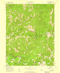 1957 Petroleum1958 Print · USGSIn the mid-1950s, the borders of Wood, Ritchie, and Wirt Counties were defined by a landscape of energy extraction and rail transport. Researchers can trace family roots at Mt Carmel Ch, locate the Eaton Tunnel along the Baltimore and Ohio, or explore the namesake hills of Petroleum.4 unique versions available
 - 1957 Map of Kanawha, 1958 Print
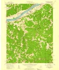
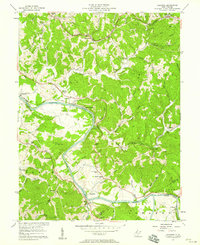 1957 Kanawha1958 Print · USGSMid-century Wood County comes to life along the winding Little Kanawha River and the busy Baltimore and Ohio rail lines. Researchers can trace the era's rural infrastructure through oil wells, the Leachtown Schools, and Kanawha Station.4 unique versions available
 - 1957 Map of Valley Mills, 1959 Print
 1957 Valley Mills1959 Print · USGSWood County at the Ohio River's edge during the late fifties reveals a landscape of river locks and rising ridgelands. Genealogists and researchers can trace family landmarks like Henderson Cem, the Boreman Sch, and the riverside community of Waverly.5 unique versions available
 - 1957 Map of Marietta, 1960 Print
 1957 Marietta1960 Print · USGSMarietta and Williamstown sit at the bustling confluence of the Muskingum and Ohio rivers during the late fifties industrial era. Researchers can trace historic sites like the Campus Martius Museum or locate family plots in the River View Cem and Putnam Cem.2 unique versions available
End of results
Showing maps 1-8 of 8
Top cities of Wood County
- Parkersburg historical maps
- Vienna historical maps
- Blennerhassett historical maps
- Williamstown historical maps
Frequently asked questions
- What are the different types of historical maps available for Wood County?
- What is the oldest map of Wood County?
- Where can I purchase historical maps of Wood County for my home or office?
- Where can I download high-res historical maps of Wood County?
- Are there historical topographic maps available for Wood County?
- Is there historical aerial imagery available for Wood County?
- Where are historical maps of Wood County sourced from?