1960s Maps of Wood County, West Virginia
Explore 11 historic maps of Wood County from the 1960s. These maps offer a rare glimpse into what life looked like during the 1960s — showing old roads, neighborhoods, homes, and landmarks that have changed or disappeared over time.
Whether you're researching your family's past, planning a metal detecting trip, or studying how Wood County's landscape evolved across the 1960s, these high-resolution maps are a powerful tool for exploring the history of this region.
- Focus on a specific era: All maps on this page are from the 1960s, giving you a focused view of this time period.
- See what’s changed: Compare century-old streets, trails, and buildings to today's modern landscape using overlays and satellite layers.
- Research with precision: Use these maps for genealogy, historical research, land use analysis, or educational projects.
- View, download, or print: Maps are fully viewable online in high resolution, and can be downloaded or printed for your own records.
Start exploring Wood County's history through authentic maps from the 1960s. This is your window into the past.
Wood County, WV maps
(11)- 1960 Map of Fleming, 1961 Print
 1960 Fleming1961 Print · USGSWashington County at the start of the 1960s shows a landscape of ridge-top farms and active energy extraction. Local historians can trace family roots at Deming Cem and Churchtown, or follow the B & O Railroad past the Tunnel at McAvan.3 unique versions available
 - 1960 Map of Coolville, 1961 Print
 1960 Coolville1961 Print · USGSThe Hocking River valley and Wayne National Forest are captured here in the early sixties, showing a landscape of ridge-top farms and timber. Genealogists can locate family landmarks such as Stewart Cem, Bethel Ch, and the Olive-Orange Township Sch.4 unique versions available
 - 1960 Map of Rockport, 1963 Print
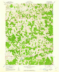
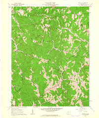
 1960 Rockport1963 Print · USGSWest Virginia's rural landscape at the start of the 1960s is captured here, showing the ridge-and-hollow settlement patterns of Wood and Jackson Counties. Genealogists can trace family names through landmarks like Naylor Cem, Rockport Sch, and Limestone Ch.2 unique versions available
 - 1960 Map of Pond Creek, 1964 Print
 1960 Pond Creek1964 Print · USGSThe Ohio River valley and the interior ridges of Jackson and Wood counties appear here just as the new decade began. Researchers can trace family history through dozens of rural landmarks, including Liberty School, Temperance Chapel, and the Reedsville Cemetery.3 unique versions available
 - 1961 Map of Clarksburg
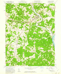
 1961 Clarksburg1961 Print · USGSThe mid-century industrial and river landscapes of West Virginia and Ohio are detailed here, centered on the Ohio River. Researchers can trace the Baltimore and Ohio rail lines connecting towns like Parkersburg, Clarksburg, and Monongah.
 - 1961 Map of Schultz, 1962 Print
 1961 Schultz1962 Print · USGSPleasants and Ritchie counties in the early sixties reveal a landscape of deep hollows and narrow ridgeline roads. Genealogists can locate family sites near Cloverdale Ch, the settlement at Maxwell, or tracing the paths along Goose Creek.3 unique versions available
 - 1961 Map of Lubeck, 1963 Print
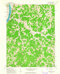
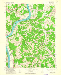 1961 Lubeck1963 Print · USGSThe West Virginia-Ohio border along the Ohio River is captured here in the early sixties, showing the vital river-and-rail infrastructure of the era. Researchers can trace family history through dozens of rural burial sites like Hickenbottom Cem or explore riverside landmarks such as Mustapha Island.4 unique versions available
 - 1961 Map of Little Hocking, 1963 Print
 1961 Little Hocking1963 Print · USGSThe Ohio River valley south of Parkersburg comes to life in the early sixties, showing the vital river-and-rail corridor at Little Hocking. Family historians can trace rural roots through Quaker Cem and Neal Cem, or locate landmarks like the Covered Bridge.4 unique versions available
 - 1961 Map of South Parkersburg, 1963 Print
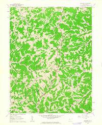
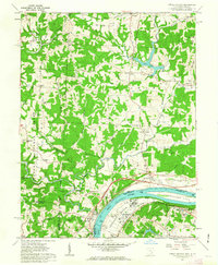
 1961 South Parkersburg1963 Print · USGSSouth Parkersburg and the surrounding Wood County ridges are captured here during a period of steady mid-century growth. Genealogists and local researchers can trace family landmarks like Mathews Cem and Gihon Ch, or follow the Baltimore and Ohio rail line.3 unique versions available
 - 1969 Map of Parkersburg, 1971 Print
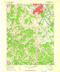
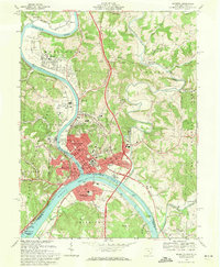
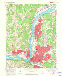 1969 Parkersburg1971 Print · USGSThe Ohio River valley thrives in the late 1960s as Parkersburg and Vienna expand their industrial and residential footprints. Genealogists and historians can trace local landmarks like Stewart Air Park, Blennerhassett Island, and St Josephs Hospital at this pivotal moment of growth.5 unique versions available
 - 1969 Map of Marietta, 1971 Print
 1969 Marietta1971 Print · USGSThe Ohio-West Virginia border comes alive in the late sixties at the historic junction of the Muskingum and Ohio Rivers. Genealogists and historians can trace the foundations of Marietta through landmarks like the Mound Cem, Harmar neighborhood, and the Campus Martius Museum.3 unique versions available
End of results
Showing maps 1-11 of 11
Top cities of Wood County
- Parkersburg historical maps
- Vienna historical maps
- Blennerhassett historical maps
- Williamstown historical maps
Frequently asked questions
- What are the different types of historical maps available for Wood County?
- What is the oldest map of Wood County?
- Where can I purchase historical maps of Wood County for my home or office?
- Where can I download high-res historical maps of Wood County?
- Are there historical topographic maps available for Wood County?
- Is there historical aerial imagery available for Wood County?
- Where are historical maps of Wood County sourced from?