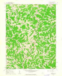
1960 Map of Rockport
USGS Topo · Published 1963About this map
The community of Rockport serves as a central hub on this 1960 survey, situated at the confluence of several drainages including Rockcamp Run and Burns Run. The landscape is defined by its deep, wooded ridges like Bogal Ridge and Limestone Ridge, which dictate the winding paths of rural roads and the placement of long-standing community landmarks. Genealogists will find a high density of family-named cemeteries and rural congregations, including the Beechgrove Ch and Beechgrove Cem in the southwestern corner, and Mt Moriah Ch near the eastern boundary.
Find a feature on this map
78 named features on this map. Tap any name to fly to it.
Don’t see what you’re looking for? This feature index may not catch every label — zoom into the map to look around manually.
Map Details
Editions of this 1960 Rockport Map
2 editions found
Other maps of this area

1906 · Elizabeth
USGS Topo · 1:62,500

1906 · Belleville
USGS Topo · 1:62,500

1907 · Spencer
USGS Topo · 1:62,500

1907 · Ripley
USGS Topo · 1:62,500

1924 · Belleville
USGS Topo · 1:62,500

1924 · Elizabeth
USGS Topo · 1:62,500

1926 · Elizabeth
USGS Topo · 1:62,500

1926 · Belleville
USGS Topo · 1:62,500

1926 · Ripley
USGS Topo · 1:62,500

1928 · Spencer
USGS Topo · 1:62,500