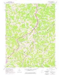
1960 Map of Rockport
USGS Topo · Published 1977About this map
Rockport sits at the center of this map where Rockcamp Run and Burns Run converge near the border of Wood and Wirt counties. The landscape is defined by a dense network of ridges and runs, including Central Ridge and Stephens Ridge, illustrating the deeply dissected terrain characteristic of the region. Numerous gas wells are scattered throughout the valleys, particularly along Pond Creek and Indian Run, reflecting the area's mid-century energy production history. Family and local history researchers will find a high density of small burial grounds and rural congregations, such as Sarepta Church, Lowdell Cemetery, and the Prosperity Cemetery Church. The map also captures the path of a major telephone pipeline and road trails like the Fivemile Trail, which wind through the township of Steele and into Tucker and Grant.
Find a feature on this map
83 named features on this map. Tap any name to fly to it.
Don’t see what you’re looking for? This feature index may not catch every label — zoom into the map to look around manually.
Map Details
Editions of this 1960 Rockport Map
2 editions found
Other maps of this area

1906 · Elizabeth
USGS Topo · 1:62,500

1906 · Belleville
USGS Topo · 1:62,500

1907 · Spencer
USGS Topo · 1:62,500

1907 · Ripley
USGS Topo · 1:62,500

1924 · Belleville
USGS Topo · 1:62,500

1924 · Elizabeth
USGS Topo · 1:62,500

1926 · Elizabeth
USGS Topo · 1:62,500

1926 · Belleville
USGS Topo · 1:62,500

1926 · Ripley
USGS Topo · 1:62,500

1928 · Spencer
USGS Topo · 1:62,500