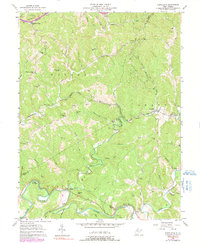
1957 Map of Petroleum
USGS Topo · Published 1991About this map
Petroleum and Volcano anchor a landscape defined by the early industrial development of West Virginia’s oil and gas fields. The Baltimore And Ohio railroad cuts through the center of the sheet, connecting settlements like Eaton to larger markets, while numerous Oil Well and Gas Wells labels indicate the intensive resource extraction underway in the hills. The terrain is deeply dissected by a network of runs including Walker Creek, Goose Creek, and Oil Spring Run, which flow toward the Hughes River in the south.
Find a feature on this map
62 named features on this map. Tap any name to fly to it.
Don’t see what you’re looking for? This feature index may not catch every label — zoom into the map to look around manually.
Map Details
Editions of this 1957 Petroleum Map
4 editions found
Other maps of this area

1904 · Marietta
USGS Topo · 1:62,500

1906 · Saint Marys
USGS Topo · 1:62,500

1906 · Elizabeth
USGS Topo · 1:62,500

1907 · Harrisville
USGS Topo · 1:62,500

1924 · St Marys
USGS Topo · 1:62,500

1924 · Harrisville
USGS Topo · 1:62,500

1924 · Marietta
USGS Topo · 1:62,500

1924 · Elizabeth
USGS Topo · 1:62,500

1926 · Elizabeth
USGS Topo · 1:62,500

1926 · Harrisville
USGS Topo · 1:62,500