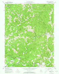
1957 Map of Petroleum
USGS Topo · Published 1973About this map
The Hughes River winds through the southern reaches of this Appalachian landscape, defining a topography shaped by deep runs and narrow ridges during the mid-20th century. This area, spanning the borders of Wood, Ritchie, and Wirt counties, is defined by its industrial and rail history. The Baltimore and Ohio railroad threads through the center of the sheet, passing through the Eaton Tunnel to serve settlements like Petroleum and Eaton.
Find a feature on this map
57 named features on this map. Tap any name to fly to it.
Don’t see what you’re looking for? This feature index may not catch every label — zoom into the map to look around manually.
Map Details
Editions of this 1957 Petroleum Map
4 editions found
Other maps of this area

1904 · Marietta
USGS Topo · 1:62,500

1906 · Saint Marys
USGS Topo · 1:62,500

1906 · Elizabeth
USGS Topo · 1:62,500

1907 · Harrisville
USGS Topo · 1:62,500

1924 · St Marys
USGS Topo · 1:62,500

1924 · Harrisville
USGS Topo · 1:62,500

1924 · Marietta
USGS Topo · 1:62,500

1924 · Elizabeth
USGS Topo · 1:62,500

1926 · Elizabeth
USGS Topo · 1:62,500

1926 · Harrisville
USGS Topo · 1:62,500