1960s Maps of Oceana, West Virginia
Explore 3 historic maps of Oceana from the 1960s. These maps offer a rare glimpse into what life looked like during the 1960s — showing old roads, neighborhoods, homes, and landmarks that have changed or disappeared over time.
Whether you're researching your family's past, planning a metal detecting trip, or studying how Oceana's landscape evolved across the 1960s, these high-resolution maps are a powerful tool for exploring the history of this region.
- Focus on a specific era: All maps on this page are from the 1960s, giving you a focused view of this time period.
- See what’s changed: Compare century-old streets, trails, and buildings to today's modern landscape using overlays and satellite layers.
- Research with precision: Use these maps for genealogy, historical research, land use analysis, or educational projects.
- View, download, or print: Maps are fully viewable online in high resolution, and can be downloaded or printed for your own records.
Start exploring Oceana's history through authentic maps from the 1960s. This is your window into the past.
Oceana, WV maps
(3)- 1961 Map of Bluefield
 1961 Bluefield1961 Print · USGSThe coalfields and mountain ridges of southern West Virginia and southwest Virginia are captured in the early sixties. Genealogists can trace family ties through rail-linked towns like Princeton and Richlands or along the shores of Bluestone Reservoir.
 - 1967 Map of Matheny, 1971 Print
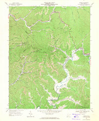
 1967 Matheny1971 Print · USGSWyoming County's coal-and-rail landscape is captured here during the late sixties, as settlements followed the narrow valleys of the Clear Fork and Laurel Fork. Genealogists and historians can trace local landmarks like Hillcrest Memorial Gardens, the Keyrock Ch, and the old Drive-in Theater near Oceana.2 unique versions available
 - 1968 Map of Oceana, 1971 Print
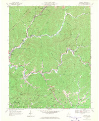
 1968 Oceana1971 Print · USGSSouthern West Virginia’s coal and gas country is captured here in the late sixties, showing the tight-knit valley communities and mountain industry. You can trace early school sites like Road Branch School or locate family-named features along Huff Creek and the Norfolk and Western line.4 unique versions available
End of results
Showing maps 1-3 of 3
Top cities near Oceana
- Welch historical maps
- Mallory historical maps
- Pineville historical maps
- Accoville historical maps
- Kopperston historical maps
- Robinette historical maps
See more
Top neighborhoods of Oceana
Frequently asked questions
- What are the different types of historical maps available for Oceana?
- What is the oldest map of Oceana?
- Where can I purchase historical maps of Oceana for my home or office?
- Where can I download high-res historical maps of Oceana?
- Are there historical topographic maps available for Oceana?
- Is there historical aerial imagery available for Oceana?
- Where are historical maps of Oceana sourced from?