1900s (20th Century) Maps of Adams County, Wisconsin
Explore 39 historic maps of Adams County from the 1900s (20th Century). These maps offer a rare glimpse into what life looked like during the 1900s — showing old roads, neighborhoods, homes, and landmarks that have changed or disappeared over time.
Whether you're researching your family's past, planning a metal detecting trip, or studying how Adams County's landscape evolved across the 1900s, these high-resolution maps are a powerful tool for exploring the history of this region.
- Focus on a specific era: All maps on this page are from the 1900s, giving you a focused view of this time period.
- See what’s changed: Compare century-old streets, trails, and buildings to today's modern landscape using overlays and satellite layers.
- Research with precision: Use these maps for genealogy, historical research, land use analysis, or educational projects.
- View, download, or print: Maps are fully viewable online in high resolution, and can be downloaded or printed for your own records.
Start exploring Adams County's history through authentic maps from the 1900s. This is your window into the past.
Adams County, WI maps
(39)- 1901 Map of The Dells
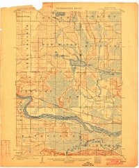
 1901 The Dells1901 Print · USGSSauk County and the Wisconsin River Dells were already becoming a destination at the turn of the century. Trace the early rail lines and river landmarks like Mirror Lake, Kilbourn, and the distinctive Elephants Back.6 unique versions available
 - 1902 Map of Briggsville
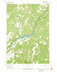
 1902 Briggsville1902 Print · USGSThe Wisconsin River valley at the turn of the century shows a landscape of river-and-rail industry. Trace the early township developments of Lewiston and Douglas, or locate original landmarks like the Levee and Big Spring.4 unique versions available
 - 1953 Map of Eau Claire, 1965 Print
 1953 Eau Claire1965 Print · USGSWest-central Wisconsin in the mid-fifties shows a landscape of river-valley industry and vast wildlife refuges during the transition from rails to modern highways. Genealogists and historians can trace the rail corridors of the Chicago and North Western or locate family-named landmarks like Decorah Mound and Chippewa Island.4 unique versions available
 - 1955 Map of Green Bay, 1968 Print
 1955 Green Bay1968 Print · USGSCentral and Eastern Wisconsin are captured here in the mid-fifties, showing the industrial growth of the Fox Valley and Wisconsin River corridors. Genealogists and historians can trace rail lines like the Green Bay and Western through settlements like Weyauwega, Clintonville, and Pulaski.2 unique versions available
 - 1957 Map of Wisconsin Dells, 1959 Print
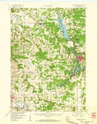 1957 Wisconsin Dells1959 Print · USGSThe Wisconsin River corridor is captured here in the mid-fifties as tourism and rail transport shaped the local economy. Genealogists and historians can trace numerous rural school sites like Jopp Sch and family landmarks such as Louie Bluff or Webster Prairie Cem.
 - 1957 Map of Madison, 1967 Print
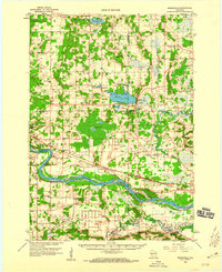
 1957 Madison1967 Print · USGSSouth-central Wisconsin in the mid-fifties reveals a landscape of industrial hubs and glacial lakes linked by a dense rail and highway network. Genealogists and historians can trace the development of lakeside communities and find notable sites like Badger Ordnance Works and the Horicon National Wildlife Refuge.3 unique versions available
 - 1958 Map of Eau Claire
 1958 Eau Claire1958 Print · USGSWestern Wisconsin in the late fifties shows a landscape of growing regional hubs and massive wildlife refuges. Trace the rail lines of the Chicago and North Western between Eau Claire and Marshfield, or explore the terrain around Iron Mound and Lake Wissota.
 - 1958 Map of Briggsville, 1959 Print
 1958 Briggsville1959 Print · USGSThe rural landscapes of south-central Wisconsin are captured here in the late fifties, showcasing the crossroads of three counties. You can trace family history through numerous country schools like Stafford Sch and landmarks such as Douglas Ch.3 unique versions available
 - 1958 Map of Arkdale, 1960 Print
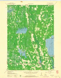
 1958 Arkdale1960 Print · USGSIn the late fifties, the central Wisconsin landscape of Adams County was defined by the massive Petenwell Flowage and rural farming life. Genealogists can trace family names at Violet Lawn Sch, Spring Branch Cem, and the settlement of Arkdale.
 - 1958 Map of Coloma, 1960 Print
 1958 Coloma1960 Print · USGSThe Central Wisconsin sand plains are shown during the late 1950s as small towns like Plainfield and Coloma flourished along the Chicago and North Western rail line. Genealogists can locate rural schoolhouses such as Rathermel Sch and family landmarks like Owens Rock.
 - 1958 Map of Necedah, 1960 Print
 1958 Necedah1960 Print · USGSJuneau County in the late fifties shows a landscape shaped by massive water projects and conservation efforts. Genealogists and hikers can trace old country roads to find the Rockview Sch, Zion Cem, and the tracks of the Chicago and North Western.3 unique versions available
 - 1960 Map of Madison
 1960 Madison1960 Print · USGSCentral and Southern Wisconsin are captured in the late fifties, showing the region as its rail-and-river network matured. Trace the paths of the Soo Line RR or locate family roots near Lake Mendota and Horicon National Wildlife Refuge.2 unique versions available
 - 1961 Map of Oxford, 1963 Print
 1961 Oxford1963 Print · USGSMarquette and Adams counties are shown here in the early sixties, a landscape of glacial lakes and small farming townships. Genealogists and historians can trace the locations of St Methodius Ch, Lincoln Sch, and the winding Chicago and North Western rail line.2 unique versions available
 - 1961 Map of Adams, 1963 Print
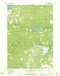
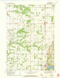
 1961 Adams1963 Print · USGSCentral Wisconsin at the start of the sixties reveals a landscape shaped by the Castle Rock Flowage and prominent glacial mounds. Researchers can locate vanished rural landmarks like Castle Rock Sch, the Woodside Ranch, and historic country cemeteries.2 unique versions available
 - 1964 Map of Eau Claire
 1964 Eau Claire1964 Print · USGSWest-central Wisconsin in the mid-1960s was a hub of river-driven industry and expanding rail networks. Researchers can trace historic homesteads near Menomonie, follow the Soo Line RR through Marshfield, or explore the grounds of the Camp McCoy Military Reservation.
 - 1967 Map of Roche A Cri, 1969 Print
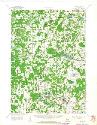
 1967 Roche A Cri1969 Print · USGSThe sandstone bluffs and prairie flats of Adams County are captured here in the late sixties, during the peak of the region's mid-century rural development. Trace local landmarks like Rabbit Rock, the Pineland Sch, and the quiet Cottonville Cem along the creek.2 unique versions available
 - 1967 Map of Arkdale NE, 1969 Print
 1967 Arkdale NE1969 Print · USGSCentral Wisconsin in the late 1960s shows a landscape of growing recreational lakes and established rural townships like Rome and Big Flats. Genealogists and local historians can locate Spring Branch Cem, Zion Ch, and the high point at Dorro Couche Lookout Tower.2 unique versions available
 - 1967 Map of Arkdale, 1969 Print
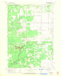
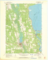
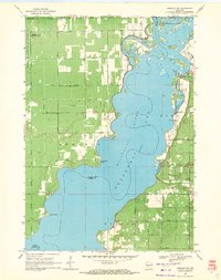
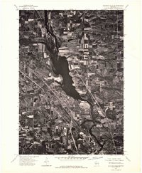
 1967 Arkdale1969 Print · USGSAdams County in the late sixties reveals a landscape transformed by the Wisconsin River reservoirs. Genealogists can locate several local burial grounds including Monroe Center Cem and East Arkdale Cem, or trace the rural road network near Arkdale.3 unique versions available
 - 1968 Map of Coloma NW, 1971 Print
 1968 Coloma NW1971 Print · USGSAdams County land and the Portage County line are shown here in the late sixties as the rural road grid matured. Genealogists and local historians can locate Holliday Cemetery, Coloma-Leola Cemetery, and landmarks like Owens Rock.2 unique versions available
 - 1968 Map of Coloma SW, 1971 Print
 1968 Coloma SW1971 Print · USGSAdams County’s wetland landscapes are captured here in the late sixties, showing the intersection of four townships amidst a network of glacial creeks. Local historians can locate the Indian Cem or trace the geography around Ship Rock and Big Roche a Cri Creek.2 unique versions available
 - 1968 Map of Coloma, 1971 Print
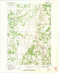 1968 Coloma1971 Print · USGSThe rural landscape of Waushara County in the late sixties is defined by its small settlements and distinct township boundaries. Genealogists and local historians can locate several country burial grounds like White Cem and the De George Sch, while tracing the path of the Old Railroad Grade.
 - 1968 Map of Hancock, 1971 Print
 1968 Hancock1971 Print · USGSCentral Wisconsin farmland at the close of the sixties reveals a detailed grid of rural life across the Adams and Waushara county line. Genealogists and local historians can trace the plots near Plainfield, locate the Plainfield Cemetery, and see the early layout of the Fish Hatchery.2 unique versions available
 - 1969 Map of Necedah, 1971 Print
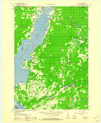
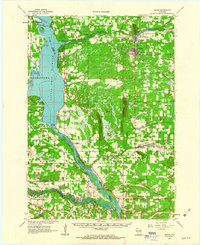
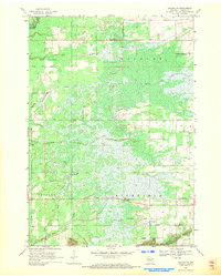
 1969 Necedah1971 Print · USGSThe village of Necedah sits at the intersection of rail and river during the late sixties, flanked by massive wildlife refuges and the Wisconsin River. Researchers can locate the Queen of the Holy Rosary Shrine, the Rockview Sch, and the high ground of Necedah Bluff.
 - 1969 Map of Arkdale NW, 1971 Print
 1969 Arkdale NW1971 Print · USGSThe shorelines of the Wisconsin River define the local landscape during the late sixties, where recreation and military activity exist side-by-side. Trace old landmarks like Cranberry Rock Lookout Tower, the settlement at New Rome, and the expansive National Guard Bombing and Gunnery Range.3 unique versions available
 - 1975 Map of Wisconsin Dells NE, 1976 Print
 1975 Wisconsin Dells NE1976 Print · USGSThe northern reaches of the Dells region are captured in the mid-seventies, showing the vast Wisconsin River corridor and its surrounding agricultural plains. Genealogists and local historians can trace the rural landscape near Plainville and study original field patterns and timber stands from this period.2 unique versions available
Showing maps 1-25 of 39
Top cities of Adams County
- Adams historical maps
- Dell Prairie historical maps
- Easton historical maps
- Strongs Prairie historical maps
- Big Flats historical maps
- Friendship historical maps
Frequently asked questions
- What are the different types of historical maps available for Adams County?
- What is the oldest map of Adams County?
- Where can I purchase historical maps of Adams County for my home or office?
- Where can I download high-res historical maps of Adams County?
- Are there historical topographic maps available for Adams County?
- Is there historical aerial imagery available for Adams County?
- Where are historical maps of Adams County sourced from?