1970s Maps of Adams County, Wisconsin
Explore 7 historic maps of Adams County from the 1970s. These maps offer a rare glimpse into what life looked like during the 1970s — showing old roads, neighborhoods, homes, and landmarks that have changed or disappeared over time.
Whether you're researching your family's past, planning a metal detecting trip, or studying how Adams County's landscape evolved across the 1970s, these high-resolution maps are a powerful tool for exploring the history of this region.
- Focus on a specific era: All maps on this page are from the 1970s, giving you a focused view of this time period.
- See what’s changed: Compare century-old streets, trails, and buildings to today's modern landscape using overlays and satellite layers.
- Research with precision: Use these maps for genealogy, historical research, land use analysis, or educational projects.
- View, download, or print: Maps are fully viewable online in high resolution, and can be downloaded or printed for your own records.
Start exploring Adams County's history through authentic maps from the 1970s. This is your window into the past.
Adams County, WI maps
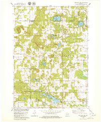
(7)- 1975 Map of Wisconsin Dells NE, 1976 Print
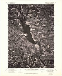 1975 Wisconsin Dells NE1976 Print · USGSThe northern reaches of the Dells region are captured in the mid-seventies, showing the vast Wisconsin River corridor and its surrounding agricultural plains. Genealogists and local historians can trace the rural landscape near Plainville and study original field patterns and timber stands from this period.2 unique versions available
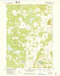
 - 1975 Map of Big Spring, 1978 Print
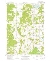 1975 Big Spring1978 Print · USGSSettled between Adams and Columbia counties in the mid-1970s, this area shows a mix of rural town halls and lakefront recreation. Genealogists can trace local roots at Davis Corners Ch or explore the early lakeside developments of Jordan Lake and Big Spring.
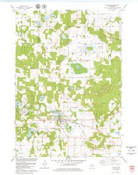
 - 1975 Map of Briggsville, 1978 Print
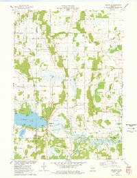 1975 Briggsville1978 Print · USGSBriggsville and the surrounding lake country are captured in the mid-seventies just as the region's recreational and agricultural identities converged. Genealogists and historians can locate the Douglas Ch, Greenwood Cem, and a local Cheese Factory near the shores of Mason Lake.
 - 1979 Map of Brooks
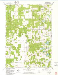 1979 Brooks1979 Print · USGSAdams County land and water are meticulously detailed in this late seventies survey, showing the area as the local fishery was established. Researchers can trace rural lineages through the New Chester Ch, the Townhall, and old lakefront tracts near Peppermill Lake.
 - 1979 Map of Westfield West
 1979 Westfield West1979 Print · USGSMarquette County's glacial landscape is captured here in the late seventies, showing the village of Westfield and several state conservation lands. Genealogists can locate family landmarks such as South Burr Oak Church, S Burr Oak Cemetery, and the Riverside Cemetery near Lawrence Lake.2 unique versions available
 - 1979 Map of Grand Marsh
 1979 Grand Marsh1979 Print · USGSGrand Marsh and its surrounding townships are shown here in the late seventies as the Chicago and North Western railway still served the local community. Genealogists can locate family landmarks like St Methodius Ch, Lincoln Sch, and Gould Rock Cem.2 unique versions available
 - 1979 Map of Oxford
 1979 Oxford1979 Print · USGSCentral Wisconsin wetlands and small-town life are captured here in the late seventies. Family historians can trace local sites like Oak Hill Cem, the village of Oxford, and the Chicago and North Western rail corridor.2 unique versions available
End of results
Showing maps 1-7 of 7
Top cities of Adams County
- Adams historical maps
- Dell Prairie historical maps
- Easton historical maps
- Strongs Prairie historical maps
- Big Flats historical maps
- Friendship historical maps
Frequently asked questions
- What are the different types of historical maps available for Adams County?
- What is the oldest map of Adams County?
- Where can I purchase historical maps of Adams County for my home or office?
- Where can I download high-res historical maps of Adams County?
- Are there historical topographic maps available for Adams County?
- Is there historical aerial imagery available for Adams County?
- Where are historical maps of Adams County sourced from?