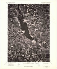
1975 Map of Wisconsin Dells NE
USGS Topo · Published 1976About this map
The Wisconsin River dominates this mid-1970s orthophotoquad, showcasing the wide, braided channels and expansive water storage as it flows through Adams County. This aerial perspective, captured in May 1975, reveals the sharp contrast between the dense woodlands along the riverbanks and the precisely surveyed agricultural grid of the surrounding uplands. The small settlement of Plainville sits as a quiet landmark amidst the farm fields that define the regional economy. Because this is an orthophotoquad rather than a traditional topographic map, the imagery provides a literal view of the vegetation patterns, rural road networks, and land use of the era, offering a clear visual record of the landscape before more modern developments altered these rural tracts.
Find a feature on this map
2 named features on this map. Tap any name to fly to it.
Don’t see what you’re looking for? This feature index may not catch every label — zoom into the map to look around manually.
Map Details
Editions of this 1975 Wisconsin Dells NE Map
2 editions found
Other maps of this area

1901 · The Dells
USGS Topo · 1:62,500

1902 · Briggsville
USGS Topo · 1:62,500

1957 · Wisconsin Dells
USGS Topo · 1:62,500

1957 · Madison
USGS Topo · 1:250,000

1958 · Briggsville
USGS Topo · 1:62,500

1960 · Madison
USGS Topo · 1:250,000

1961 · Oxford
USGS Topo · 1:62,500

1961 · Adams
USGS Topo · 1:62,500
1975 · Wisconsin Dells NW
USGS Topo · 1:24,000
1975 · Wisconsin Dells SE
USGS Topo · 1:24,000