
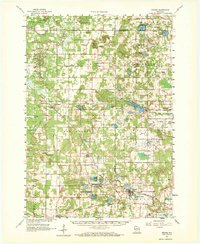
1961 Map of Oxford
USGS Topo · Published 1963About this map
The village of Oxford serves as a focal point in this 1961 survey, where the Chicago and North Western railroad provides a critical transportation corridor through a landscape defined by glacial lakes and sandstone formations. Prominent bluffs like Pilot Knob Bluff, Horseshoe Bluff, and Spring Bluff rise above the surrounding terrain, marking the geological character of the region. The map reveals a deeply established rural community, documented through numerous small-scale landmarks such as St Methodius Ch, South Burr Oak Ch, and Lincoln Sch. Significant water bodies, including Lawrence Lake, Pleasant Lake, and Neenah Creek, are central to the area's geography. Smaller settlements like Grand Marsh and Brooks are depicted with their local road networks, and many rural cemeteries like Pine Grove Cem and Gould Rock Cem provide essential data for those researching local family histories in this part of Wisconsin.
Find a feature on this map
79 named features on this map. Tap any name to fly to it.
Don’t see what you’re looking for? This feature index may not catch every label — zoom into the map to look around manually.
Map Details
Editions of this 1961 Oxford Map
2 editions found
Other maps of this area

1901 · The Dells
USGS Topo · 1:62,500

1902 · Portage
USGS Topo · 1:62,500

1902 · Briggsville
USGS Topo · 1:62,500

1955 · Green Bay
USGS Topo · 1:250,000

1957 · Wisconsin Dells
USGS Topo · 1:62,500

1957 · Madison
USGS Topo · 1:250,000

1958 · Briggsville
USGS Topo · 1:62,500

1958 · Arkdale
USGS Topo · 1:48,000

1958 · Coloma
USGS Topo · 1:48,000

1959 · Wautoma
USGS Topo · 1:48,000