
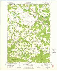
1975 Map of Wisconsin Dells NW
USGS Topo · Published 1976About this map
Lyndon Station serves as the primary hub of activity in this aerial perspective of Juneau County, situated along the critical transit corridor of the Chicago Milwaukee St Paul and Pacific railroad. Based on photography from May 1975, the imagery reveals a landscape defined by the sharp contrast between orderly agricultural fields and the wooded drainage patterns that carve through the region. This orthophotoquad captures the intersection of mid-century infrastructure and rural land use, documenting the town's footprint and the surrounding farmstead layouts before subsequent decades of development. The clear visibility of the rail line and the cluster of structures in the village provides a specific record of the community’s spatial organization during the mid-1970s.
Find a feature on this map
2 named features on this map. Tap any name to fly to it.
Don’t see what you’re looking for? This feature index may not catch every label — zoom into the map to look around manually.
Map Details
Editions of this 1975 Wisconsin Dells NW Map
2 editions found
Other maps of this area

1901 · The Dells
USGS Topo · 1:62,500

1921 · Mauston
USGS Topo · 1:62,500

1956 · Reedsburg
USGS Topo · 1:62,500

1957 · Wisconsin Dells
USGS Topo · 1:62,500

1957 · Madison
USGS Topo · 1:250,000

1958 · La Crosse
USGS Topo · 1:250,000

1960 · Madison
USGS Topo · 1:250,000

1961 · La Crosse
USGS Topo · 1:250,000

1961 · Adams
USGS Topo · 1:62,500

1962 · Mauston
USGS Topo · 1:62,500