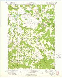
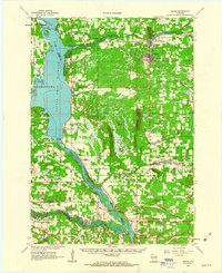
1975 Map of Lyndon Station
USGS Topo · Published 1978About this map
Lyndon Station serves as the primary hub of this landscape, situated along the line of the Chicago Milwaukee St Paul and Pacific railroad. The geography is defined by a series of prominent elevations and bluffs, including Sheep Pasture Bluff, Fairy Bluff, and the distinctive Rattlesnake Knob near the southern boundary. These features rise above the drainages of Sevenmile Creek and Tracy Creek, creating a varied topography that shifts from open flats to the intricate drainages of the Badlands and Dell Creek State Wildlife Area.
Find a feature on this map
44 named features on this map. Tap any name to fly to it.
Don’t see what you’re looking for? This feature index may not catch every label — zoom into the map to look around manually.
Map Details
Editions of this 1975 Lyndon Station Map
2 editions found
Other maps of this area

1901 · The Dells
USGS Topo · 1:62,500

1921 · Mauston
USGS Topo · 1:62,500
1956 · Reedsburg
USGS Topo · 1:62,500
1957 · Wisconsin Dells
USGS Topo · 1:62,500

1957 · Madison
USGS Topo · 1:250,000

1958 · La Crosse
USGS Topo · 1:250,000

1960 · Madison
USGS Topo · 1:250,000

1961 · La Crosse
USGS Topo · 1:250,000
1961 · Adams
USGS Topo · 1:62,500
1962 · Mauston
USGS Topo · 1:62,500