1970s Maps of Preston, Wisconsin
Explore 1 historic maps of Preston from the 1970s. These maps offer a rare glimpse into what life looked like during the 1970s — showing old roads, neighborhoods, homes, and landmarks that have changed or disappeared over time.
Whether you're researching your family's past, planning a metal detecting trip, or studying how Preston's landscape evolved across the 1970s, these high-resolution maps are a powerful tool for exploring the history of this region.
- Focus on a specific era: All maps on this page are from the 1970s, giving you a focused view of this time period.
- See what’s changed: Compare century-old streets, trails, and buildings to today's modern landscape using overlays and satellite layers.
- Research with precision: Use these maps for genealogy, historical research, land use analysis, or educational projects.
- View, download, or print: Maps are fully viewable online in high resolution, and can be downloaded or printed for your own records.
Start exploring Preston's history through authentic maps from the 1970s. This is your window into the past.
Preston, WI maps
(1)- 1979 Map of Grand Marsh
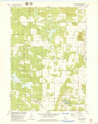 1979 Grand Marsh1979 Print · USGSGrand Marsh and its surrounding townships are shown here in the late seventies as the Chicago and North Western railway still served the local community. Genealogists can locate family landmarks like St Methodius Ch, Lincoln Sch, and Gould Rock Cem.2 unique versions available
End of results
Showing maps 1-1 of 1
Top cities near Preston
- Adams historical maps
- Lemonweir historical maps
- Easton historical maps
- Strongs Prairie historical maps
- Big Flats historical maps
- Friendship historical maps
See more
Top neighborhoods of Preston
Frequently asked questions
- What are the different types of historical maps available for Preston?
- What is the oldest map of Preston?
- Where can I purchase historical maps of Preston for my home or office?
- Where can I download high-res historical maps of Preston?
- Are there historical topographic maps available for Preston?
- Is there historical aerial imagery available for Preston?
- Where are historical maps of Preston sourced from?