1980s Maps of Morse, Wisconsin
Explore 6 historic maps of Morse from the 1980s. These maps offer a rare glimpse into what life looked like during the 1980s — showing old roads, neighborhoods, homes, and landmarks that have changed or disappeared over time.
Whether you're researching your family's past, planning a metal detecting trip, or studying how Morse's landscape evolved across the 1980s, these high-resolution maps are a powerful tool for exploring the history of this region.
- Focus on a specific era: All maps on this page are from the 1980s, giving you a focused view of this time period.
- See what’s changed: Compare century-old streets, trails, and buildings to today's modern landscape using overlays and satellite layers.
- Research with precision: Use these maps for genealogy, historical research, land use analysis, or educational projects.
- View, download, or print: Maps are fully viewable online in high resolution, and can be downloaded or printed for your own records.
Start exploring Morse's history through authentic maps from the 1980s. This is your window into the past.
Morse, WI maps
(6)- 1980 Map of Ironwood
 1980 Ironwood1980 Print · USGSThe Michigan-Wisconsin borderlands appear in the late twentieth century as a landscape defined by iron mining and deep forests. Researchers can trace the rail-and-river economy through the Soo Line and Chicago and North Western tracks connecting Mellen, Glidden, and Hurley.
 - 1984 Map of Morse
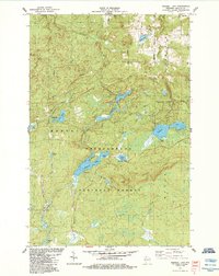
 1984 Morse1984 Print · USGSAshland County's timberlands and river headwaters are captured here in the mid-1980s. Local researchers can trace the roads around Morse and Cayuga, find the Morse Cem, or locate the crossroads at Popcorn Corners.
 - 1984 Map of Mineral Lake
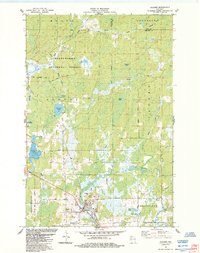
 1984 Mineral Lake1984 Print · USGSIn the mid-eighties, this portion of Ashland County was a dense mosaic of lakes and timber within the Chequamegon National Forest. Outdoor enthusiasts and researchers can trace forest roads to Mineral Lake, the Gogebic Range, and remote spots like Toskis.
 - 1984 Map of Gurney
 1984 Gurney1984 Print · USGSNorthern Wisconsin's timber and rail landscape is captured here in the 1980s as the Soo Line Railroad winds through the Bad River Indian Reservation. Researchers can trace family history through Edgewood Cem or locate old homesteads near Sedgwick and the Potato River Falls.
 - 1984 Map of Glidden
 1984 Glidden1984 Print · USGSNorthern Wisconsin timber and river country are captured here in the mid-1980s. Local researchers can trace the roads around Glidden, locate the Mt Hope Cem, and explore the hydrology of Zielke Lake and the Bad River.
 - 1984 Map of High Bridge
 1984 High Bridge1984 Print · USGSAshland County in the mid-1980s reveals a landscape where the river and rail economy shaped the rural township of Morse. Local researchers can find the Soo Line junction at High Bridge, trace family-named roads like Kleinsteiber Road, and locate the old Cem.
End of results
Showing maps 1-6 of 6
Top cities near Morse
- Ashland historical maps
- White River historical maps
- Mellen historical maps
- Morse historical maps
- Marengo historical maps
- Saxon historical maps
See more
Top neighborhoods of Morse
Frequently asked questions
- What are the different types of historical maps available for Morse?
- What is the oldest map of Morse?
- Where can I purchase historical maps of Morse for my home or office?
- Where can I download high-res historical maps of Morse?
- Are there historical topographic maps available for Morse?
- Is there historical aerial imagery available for Morse?
- Where are historical maps of Morse sourced from?