1970s Maps of Grandview, Wisconsin
Explore 7 historic maps of Grandview from the 1970s. These maps offer a rare glimpse into what life looked like during the 1970s — showing old roads, neighborhoods, homes, and landmarks that have changed or disappeared over time.
Whether you're researching your family's past, planning a metal detecting trip, or studying how Grandview's landscape evolved across the 1970s, these high-resolution maps are a powerful tool for exploring the history of this region.
- Focus on a specific era: All maps on this page are from the 1970s, giving you a focused view of this time period.
- See what’s changed: Compare century-old streets, trails, and buildings to today's modern landscape using overlays and satellite layers.
- Research with precision: Use these maps for genealogy, historical research, land use analysis, or educational projects.
- View, download, or print: Maps are fully viewable online in high resolution, and can be downloaded or printed for your own records.
Start exploring Grandview's history through authentic maps from the 1970s. This is your window into the past.
Grandview, WI maps
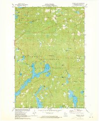
(7)- 1971 Map of Grand View, 1973 Print
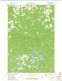 1971 Grand View1973 Print · USGSBayfield County’s forest and lake country is captured here in the early seventies, centered on the settlement of Grand View. Researchers can find the University of Wisconsin Surveying Camp, the Long Mile Lookout Tower, and an Old Railroad Grade.
 - 1971 Map of Mason, 1973 Print
 1971 Mason1973 Print · USGSThe village of Mason and the surrounding timberlands are captured here in the early seventies, just as the Bibon Marsh remains a wild contrast to local farms. Trace old transport routes including the Chicago and North Western line and an Old Railroad Grade.
 - 1971 Map of Lake Tahkodah, 1973 Print
 1971 Lake Tahkodah1973 Print · USGSThe Northwoods of Bayfield and Sawyer counties are captured here in the early seventies, dominated by the Namekagon River. You can trace the development of recreation at Mount Telemark or locate remote camps on Star Lake and Lake Tahkodah.
 - 1971 Map of Namekagon Lake, 1973 Print
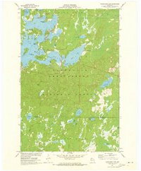 1971 Namekagon Lake1973 Print · USGSBayfield and Sawyer counties are captured in the early 1970s, showcasing the dense woods and glaciated waters of the Chequamegon National Forest. Researchers can trace the irregular shorelines of Namekagon Lake and find landmarks like Missionary Point or the small settlement at Namekagon.2 unique versions available
 - 1971 Map of Grand View NW, 1973 Print
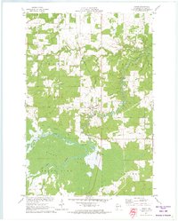
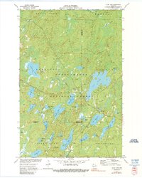
 1971 Grand View NW1973 Print · USGSBayfield County at the start of the 1970s shows a landscape defined by the expansive Bibon Marsh and the lakelands of the Northwoods. Researchers can trace the Old Railroad Grade near Sutherland or locate family sites near Pike River Cem and Bethany Ch.3 unique versions available
 - 1971 Map of Diamond Lake, 1973 Print
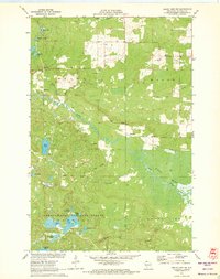
 1971 Diamond Lake1973 Print · USGSBayfield County's north woods are captured here in the early seventies, showing a landscape defined by the Chequamegon National Forest. Trace family vacation spots around Owen Lake or the old Chicago and North Western rail line.3 unique versions available
 - 1971 Map of Clam Lake, 1990 Print
 1971 Clam Lake1990 Print · USGSThe Northwoods of Ashland and Bayfield Counties come alive in this early 1970s survey of the lake-studded forestry landscape. Researchers can locate the Clam Lake Lookout Tower, trace burials at Wildwood Cem, and find the Job Corps Camp near Chippewa Lake.
End of results
Showing maps 1-7 of 7
Top cities near Grandview
- Ashland historical maps
- Sanborn historical maps
- White River historical maps
- Cable historical maps
- Drummond historical maps
- Delta historical maps
See more
Top neighborhoods of Grandview
Frequently asked questions
- What are the different types of historical maps available for Grandview?
- What is the oldest map of Grandview?
- Where can I purchase historical maps of Grandview for my home or office?
- Where can I download high-res historical maps of Grandview?
- Are there historical topographic maps available for Grandview?
- Is there historical aerial imagery available for Grandview?
- Where are historical maps of Grandview sourced from?