1940s Maps of Kelly, Wisconsin
Explore 8 historic maps of Kelly from the 1940s. These maps offer a rare glimpse into what life looked like during the 1940s — showing old roads, neighborhoods, homes, and landmarks that have changed or disappeared over time.
Whether you're researching your family's past, planning a metal detecting trip, or studying how Kelly's landscape evolved across the 1940s, these high-resolution maps are a powerful tool for exploring the history of this region.
- Focus on a specific era: All maps on this page are from the 1940s, giving you a focused view of this time period.
- See what’s changed: Compare century-old streets, trails, and buildings to today's modern landscape using overlays and satellite layers.
- Research with precision: Use these maps for genealogy, historical research, land use analysis, or educational projects.
- View, download, or print: Maps are fully viewable online in high resolution, and can be downloaded or printed for your own records.
Start exploring Kelly's history through authentic maps from the 1940s. This is your window into the past.
Kelly, WI maps
(8)- 1942 Map of Ashland
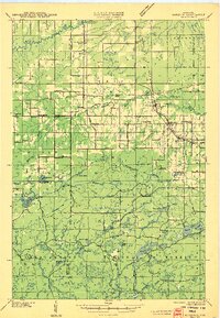
 1942 Ashland1942 Print · USGSThe South Shore of Lake Superior comes alive in the early 1940s, showing the bustling rail hubs and maritime ports of Chequamegon Bay. Genealogists and historians can trace local family roots through sites like Northland College, St Agnes Cem, and Ondassagon Sch.
 - 1942 Map of Marengo, 1964 Print
 1942 Marengo1964 Print · USGSNorthern Wisconsin's timber and rail landscape is captured here in the early 1940s, showing the intersection of federal forest land and tribal territory. Genealogists can locate specific rural schools like Maple Ridge Sch and communities like Sanborn or North York.
 - 1944 Map of Moquah, 1952 Print
 1944 Moquah1952 Print · USGSBayfield County at the end of the Second World War shows a landscape of timber-town history and rural school districts. Genealogists and historians can trace the foundations of Moquah, locate family-named schoolhouses like Gednota Sch, and follow the long-vanished Old Grade logging routes.2 unique versions available
 - 1944 Map of Grandview, 1962 Print
 1944 Grandview1962 Print · USGSBayfield County's Northwoods landscape is captured here during the mid-forties, showing the intricate network of rails and rural schools. Genealogists and historians can locate the Taylor Lake CCC Camp and trace family roots near Becker Sch, Grandview, and Mason.
 - 1945 Map of Marengo
 1945 Marengo1945 Print · USGSAshland County and the Chequamegon National Forest are captured here in the mid-1940s, showing a landscape shaped by timber and rail. Researchers can locate rural landmarks like Ebenezer Ch and vanished local schools including Agnew Sch and Section Five Sch.2 unique versions available
 - 1947 Map of Moquah
 1947 Moquah1947 Print · USGSBayfield County in the late 1940s reveals a landscape of rural schoolhouses and forest management hubs like the Brinks Ranger Sta. Genealogists and historians can trace family locations near Hillsdale Sch, Gednota Sch, and the rail stop at Ino Sta.
 - 1947 Map of Ashland
 1947 Ashland1947 Print · USGSCoastal Wisconsin thrived on the shores of Lake Superior in the late 1940s, balancing industrial power with small-town education. Genealogists can trace family roots through numerous country schools like Olson Sch and local sites like St Agnes Cem.
 - 1947 Map of Grandview
 1947 Grandview1947 Print · USGSBayfield County at the close of the 1940s reveals a landscape of timber-towns and marshlands connected by the Chicago St Paul Minneapolis and Omaha rail line. Researchers can locate remote rural schoolhouses like Becker Sch and Dybedal Sch, or trace the winding course of the White River.
End of results
Showing maps 1-8 of 8
Top cities near Kelly
- Ashland historical maps
- Washburn historical maps
- Sanborn historical maps
- White River historical maps
- Cable historical maps
- Drummond historical maps
See more
Frequently asked questions
- What are the different types of historical maps available for Kelly?
- What is the oldest map of Kelly?
- Where can I purchase historical maps of Kelly for my home or office?
- Where can I download high-res historical maps of Kelly?
- Are there historical topographic maps available for Kelly?
- Is there historical aerial imagery available for Kelly?
- Where are historical maps of Kelly sourced from?